IMAGES TAKEN NEAR TO
The Orchards, NOTTINGHAM, NG14 7DP
Introduction
This page details the photographs taken nearby to The Orchards, NG14 7DP by members of the Geograph project.
The Geograph project started in 2005 with the aim of publishing, organising and preserving representative images for every square kilometre of Great Britain, Ireland and the Isle of Man.

There are currently over 7.5m images from over14,400 individuals and you can help contribute to the project by visiting https://www.geograph.org.uk
Image Map
Images are licensed for reuse under creativecommons.org/licenses/by-sa/2.0
Notes
- Clicking on the map will re-center to the selected point.
- The higher the marker number, the further away the image location is from the centre of the postcode.
Image Listing (100 Images Found)
Images are licensed for reuse under creativecommons.org/licenses/by-sa/2.0
Image
Details
Distance
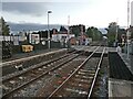
1
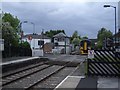
Train approaching Lowdham railway station
Image: © Andrew Abbott
Taken: 16 May 2008
0.02 miles
2

The site of Lowdham signal box
Essentially the same viewpoint as https://www.geograph.org.uk/photo/6320971 , the yellow bags indicating the actual site.
The box has been preserved as part of the display of railwayana (Lowdham Railway Heritage) by the occupier of the former railway station. It was moved intact during the night of 24 October 2020 by being lifted by crane onto a low-loader lorry, and redeposited alongside the station building at the rear of the northbound platform http://www.geograph.org.uk/photo/6695965.
Some views of the move can be found here https://www.railinsider.co.uk/2020/11/13/signal-box-moves-100-metres-overnight/#:~:text=The%20signal%20box%20at%20Lowdham,stood%20for%20over%20120%20years.
Image: © Alan Murray-Rust
Taken: 2 Dec 2020
0.02 miles
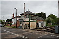
4
Lowdham signal box
On this occasion, the signal box had no trains to control as none was running due to the Nottingham area resignalling project.
Image: © Richard Vince
Taken: 24 Aug 2013
0.02 miles
5
Lowdham level crossing
The presence of 4 lifting barriers indicates that this is not a fully automatic crossing. Since 2016 however it has been controlled from a remote signalling centre, with lidar detection of obstructions.
Image: © Alan Murray-Rust
Taken: 10 Nov 2019
0.02 miles
7
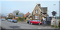
Lowdham, Notts.
The former dual-purpose station master's house and station building (ticket office etc.) at the side of Station Road. The ramp, plus the white gate, provides access for passengers onto the platform serving trains travelling towards Newark. This building passed into private ownership in 1990. The white van on the left approaching the level crossing on the right is coming from the direction of the A612 (the Nottingham-Southwell road).
Image: © David Hallam-Jones
Taken: 28 Feb 2014
0.02 miles
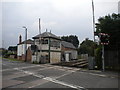
8
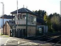
Lowdham Signal Box
Now redundant following the introduction of centralised signalling in 2016.
Image: © Alan Murray-Rust
Taken: 10 Nov 2019
0.03 miles
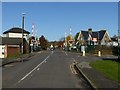
9
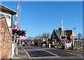
Level crossing on Gunthorpe Road
In the Nottinghamshire village of Lowdham.
Image: © Mat Fascione
Taken: 25 Mar 2016
0.03 miles
10
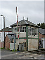
Lowdham Signal Box
Earmarked for closure some time during 2014. An original Midland railway type.
Image: © Alan Murray-Rust
Taken: 6 Apr 2014
0.03 miles