IMAGES TAKEN NEAR TO
The Green, NOTTINGHAM, NG14 7DD
Introduction
This page details the photographs taken nearby to The Green, NG14 7DD by members of the Geograph project.
The Geograph project started in 2005 with the aim of publishing, organising and preserving representative images for every square kilometre of Great Britain, Ireland and the Isle of Man.

There are currently over 7.5m images from over14,400 individuals and you can help contribute to the project by visiting https://www.geograph.org.uk
Image Map
Images are licensed for reuse under creativecommons.org/licenses/by-sa/2.0
Notes
- Clicking on the map will re-center to the selected point.
- The higher the marker number, the further away the image location is from the centre of the postcode.
Image Listing (3 Images Found)
Images are licensed for reuse under creativecommons.org/licenses/by-sa/2.0
Image
Details
Distance
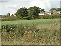
1

Near Lowdham Grange
These houses were built as staff quarters for the then borstal at Lowdham Grange.
Image: © Alan Murray-Rust
Taken: 17 Oct 2008
0.12 miles
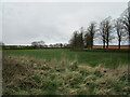
2
Lowdham Grange
The housing is staff quarters attached to Lowdham Grange Prison.
Image: © Alan Murray-Rust
Taken: 17 Oct 2008
0.13 miles
3
Avenue and staff housing, HMP Lowdham Grange
Image: © Jonathan Thacker
Taken: 10 Apr 2021
0.17 miles