IMAGES TAKEN NEAR TO
The Leys, NOTTINGHAM, NG14 7BT
Introduction
This page details the photographs taken nearby to The Leys, NG14 7BT by members of the Geograph project.
The Geograph project started in 2005 with the aim of publishing, organising and preserving representative images for every square kilometre of Great Britain, Ireland and the Isle of Man.

There are currently over 7.5m images from over14,400 individuals and you can help contribute to the project by visiting https://www.geograph.org.uk
Image Map
Images are licensed for reuse under creativecommons.org/licenses/by-sa/2.0
Notes
- Clicking on the map will re-center to the selected point.
- The higher the marker number, the further away the image location is from the centre of the postcode.
Image Listing (48 Images Found)
Images are licensed for reuse under creativecommons.org/licenses/by-sa/2.0
Image
Details
Distance
1

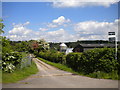
A6097, Lowdham bypass
This was a relatively early village bypass, part of the improvements to the road which included Gunthorpe Bridge.
Image: © Alan Murray-Rust
Taken: 17 Oct 2008
0.03 miles
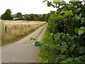
2
Track to Lowdham Mill
Seen from the A6097 on the northern edge of Lowdham. The track is also a public bridleway, though on this occasion the sign was somewhat obscured by that of an estate agent.
Image: © Richard Vince
Taken: 14 May 2014
0.10 miles

4

View towards The Hut
From the bypass, close to the footpath to the Church. The Hut is a late 20th century building in classical style.
Image: © Alan Murray-Rust
Taken: 17 Oct 2008
0.13 miles
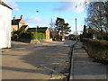
6

Footpath to the church
Lowdham Church is on the outskirts of the village, doubtless due to the location of the castle. This path is the most direct pedestrian access from the northern part of the village, which would account for it being so well engineered.
Image: © Alan Murray-Rust
Taken: 17 Oct 2008
0.15 miles
8
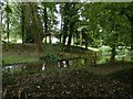
Medieval castle motte and moat, Lowdham
The motte was excavated in the late 1930s indicating the presence of a stone keep, possibly 14th century. The re-creation of a watered moat appears to be modern. The site is not scheduled.
Image: © Alan Murray-Rust
Taken: 13 Jun 2020
0.16 miles
9

Looking towards Gonalston back lane from fields at end of Mount Pleasant Lowdham
Image: © Joy Newbould
Taken: 26 Aug 2013
0.16 miles
10

Castle mound, Lowdham
Difficult to distinguish in a photograph, but the ground does rise from a moat to a plateau. Marked on the 1:25000 map, but apparently not listed as an ancient monument.
Image: © Alan Murray-Rust
Taken: 17 Oct 2008
0.17 miles