IMAGES TAKEN NEAR TO
Ton Lane, NOTTINGHAM, NG14 7AR
Introduction
This page details the photographs taken nearby to Ton Lane, NG14 7AR by members of the Geograph project.
The Geograph project started in 2005 with the aim of publishing, organising and preserving representative images for every square kilometre of Great Britain, Ireland and the Isle of Man.

There are currently over 7.5m images from over14,400 individuals and you can help contribute to the project by visiting https://www.geograph.org.uk
Image Map
Images are licensed for reuse under creativecommons.org/licenses/by-sa/2.0
Notes
- Clicking on the map will re-center to the selected point.
- The higher the marker number, the further away the image location is from the centre of the postcode.
Image Listing (66 Images Found)
Images are licensed for reuse under creativecommons.org/licenses/by-sa/2.0
Image
Details
Distance
1

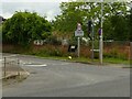
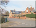
Ton Lane
The exit from the village towards the Church and then Lambley. Note the new houses at the left which incorporate some vernacular style of brickwork.
Image: © Alan Murray-Rust
Taken: 17 Oct 2008
0.03 miles
2
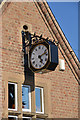
Lowdham Old School Clock
Lowdham Cof E infant school - now converted into apartments but the old school clock still remains and is a feature of this Nottinghamshire village
Image: © Joy Newbould
Taken: 26 Aug 2013
0.03 miles
3
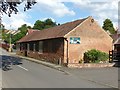
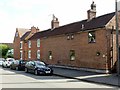
Former framework knitters' workshops, Lowdham
One of a pair of buildings on the corner of Ton Lane and Main Street, now occupied by a soft furnishings firm. Early 19th century, Listed Grade II.
Image: © Alan Murray-Rust
Taken: 13 Jun 2020
0.05 miles
4
Ton Lane Lowdham
Recreating this 'First' for the square https://www.geograph.org.uk/photo/35716
Image: © Alan Murray-Rust
Taken: 15 Jul 2021
0.05 miles
5
Former framework knitters' workshops, Lowdham
One of a pair of buildings on the corner of Ton Lane and Main Street, now occupied by a soft furnishings firm. Early 19th century, Listed Grade II.
Image: © Alan Murray-Rust
Taken: 13 Jun 2020
0.06 miles
6

Retail conversion
This range of buildings has been converted into 3 or 4 specialist retail outlets. The nearest one deals in soft furnishings.
Image: © Alan Murray-Rust
Taken: 17 Oct 2008
0.06 miles
7
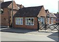
Lowdham, Notts.
With solar panels in place, this is the former primary school in Main Street that was in use until 1988. Part of the building is now a private residence, whilst another part of it houses the village library. The clock was paid for by public subscription and installed to commemorate George V's coronation. The house on the right was the previously the head teacher's house but it is now privately owned. Although this picture gives the impression that these two buildings are joined, they are in fact separated by a path.
Image: © David Hallam-Jones
Taken: 28 Feb 2014
0.06 miles
8
Holly Tree Cottage and no.67 Main Street, Lowdham
There is a benchmark http://www.geograph.org.uk/photo/6509416 on no.67 under the nearer white window.
Image: © Alan Murray-Rust
Taken: 13 Jun 2020
0.06 miles
9
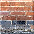
Bench mark, 67 Main Street, Lowdham
See http://www.geograph.org.uk/photo/6509414 for location.
Image: © Alan Murray-Rust
Taken: 13 Jun 2020
0.06 miles
10
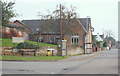
Lowdham, Notts.
The clocked-adorned village library site on Main Street with the local health centre to its rear on Francklin Road. The Francklin family, of nearby Gonalston Hall, were (are?) local landowners. John Henry Browne, who became the vicar in 1842, was instrumental in restoring the then neglected church and raising money and grants to build the village school. This former school building - with the clock - was in use until 1988 when a modern, replacement primary school was built elsewhere in the village. The clock was paid for by public subscription to commemorate George V's coronation.
Image: © David Hallam-Jones
Taken: 28 Feb 2014
0.07 miles