IMAGES TAKEN NEAR TO
Old Kennel Drive, NOTTINGHAM, NG14 6SH
Introduction
This page details the photographs taken nearby to Old Kennel Drive, NG14 6SH by members of the Geograph project.
The Geograph project started in 2005 with the aim of publishing, organising and preserving representative images for every square kilometre of Great Britain, Ireland and the Isle of Man.

There are currently over 7.5m images from over14,400 individuals and you can help contribute to the project by visiting https://www.geograph.org.uk
Image Map
Images are licensed for reuse under creativecommons.org/licenses/by-sa/2.0
Notes
- Clicking on the map will re-center to the selected point.
- The higher the marker number, the further away the image location is from the centre of the postcode.
Image Listing (7 Images Found)
Images are licensed for reuse under creativecommons.org/licenses/by-sa/2.0
Image
Details
Distance
1
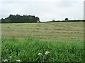
Cut grass in a field west of Salterford Lane
Haymaking or for silage?
Image: © Christine Johnstone
Taken: 5 Jun 2013
0.15 miles
2
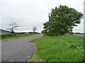
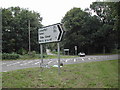
Salterford Lane
Heading south-east towards Salterford Farm and Calverton.
Image: © Christine Johnstone
Taken: 5 Jun 2013
0.16 miles
3
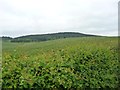
Rolling farmland east of Salterford Lane
With the wooded Darncliff Hill in the distance.
Image: © Christine Johnstone
Taken: 5 Jun 2013
0.18 miles
4
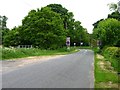
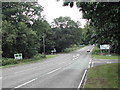
Salterford Lane meeting the A614
The lane has been bent, to create two safer right-angled junctions, rather than one oblique crossroads.
Image: © Christine Johnstone
Taken: 5 Jun 2013
0.19 miles
7
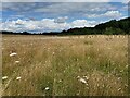
Natural burial ground near Calverton
The present extent of Tithe Green natural burial ground. The unbroken expanse of grasses and wildflowers, and the quietness, brought visitors to a hush but one vehicle in the view was a reminder of the site's purpose.
Image reference: 7552344
Image: © Robin Stott
Taken: 24 Jul 2023
0.24 miles