IMAGES TAKEN NEAR TO
Smithy Close, NOTTINGHAM, NG14 6RX
Introduction
This page details the photographs taken nearby to Smithy Close, NG14 6RX by members of the Geograph project.
The Geograph project started in 2005 with the aim of publishing, organising and preserving representative images for every square kilometre of Great Britain, Ireland and the Isle of Man.

There are currently over 7.5m images from over14,400 individuals and you can help contribute to the project by visiting https://www.geograph.org.uk
Image Map
Images are licensed for reuse under creativecommons.org/licenses/by-sa/2.0
Notes
- Clicking on the map will re-center to the selected point.
- The higher the marker number, the further away the image location is from the centre of the postcode.
Image Listing (71 Images Found)
Images are licensed for reuse under creativecommons.org/licenses/by-sa/2.0
Image
Details
Distance
1
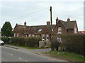
Wood's Foundation School, second generation
Built in 1878 and in use until 1969 when the present school opened. It is now converted into private dwellings.
Image: © Alan Murray-Rust
Taken: 20 Mar 2011
0.03 miles
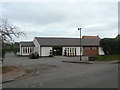
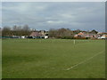
2
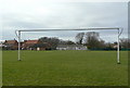
Woodborough playing fields
Looking towards the village hall and the pavilion.
Image: © Alan Murray-Rust
Taken: 20 Mar 2011
0.04 miles
3
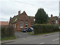
Wood's Foundation School, second generation
Built in 1878 (note the date in the gable) and in use until 1969 when the present school opened. It is now converted into private dwellings.
Image: © Alan Murray-Rust
Taken: 20 Mar 2011
0.04 miles
4
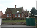
Wood's Foundation School, second generation
Built in 1878 and in use until 1969 when the present school opened. It is now converted into private dwellings.
Image: © Alan Murray-Rust
Taken: 20 Mar 2011
0.04 miles
5
Woodborough Village Hall
Construction began in 1973, and it is now a focal point for many village activities.
Image: © Alan Murray-Rust
Taken: 20 Mar 2011
0.04 miles
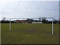
7
Woodborough playing fields
The designated line of the public footpath follows the perimeter as the notice requests.
Image: © Alan Murray-Rust
Taken: 20 Mar 2011
0.05 miles
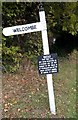
8
Welcombe
The attached sign suggests that there might be a permissive path here, but it seems to be simply a more than usually expansive house sign. The access pointed to is certainly just the drive to an ordinary house.
Image: © Alan Murray-Rust
Taken: 20 Mar 2011
0.05 miles
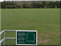
9
Woodborough playing fields
The cricket square in the foreground, with the village and church as backdrop.
Image: © Alan Murray-Rust
Taken: 20 Mar 2011
0.05 miles
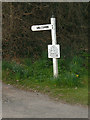
10
Welcombe to our house
The sign may imply a track to a village, or hamlet? Not quite, it seems to lead to a modest country home.
Image: © Chris Morgan
Taken: 25 Oct 2016
0.06 miles