IMAGES TAKEN NEAR TO
Whitedale Road, NOTTINGHAM, NG14 6RQ
Introduction
This page details the photographs taken nearby to Whitedale Road, NG14 6RQ by members of the Geograph project.
The Geograph project started in 2005 with the aim of publishing, organising and preserving representative images for every square kilometre of Great Britain, Ireland and the Isle of Man.

There are currently over 7.5m images from over14,400 individuals and you can help contribute to the project by visiting https://www.geograph.org.uk
Image Map
Images are licensed for reuse under creativecommons.org/licenses/by-sa/2.0
Notes
- Clicking on the map will re-center to the selected point.
- The higher the marker number, the further away the image location is from the centre of the postcode.
Image Listing (28 Images Found)
Images are licensed for reuse under creativecommons.org/licenses/by-sa/2.0
Image
Details
Distance
1
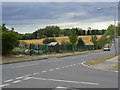
Collyer Road
At the junction with Park Road, the end of the housing development. On the left is a small group of allotment gardens.
Image: © Alan Murray-Rust
Taken: 14 Aug 2011
0.06 miles
2
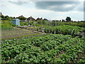
Allotments at Calverton
A fine crop of spuds in the foreground! View from Collyer Road.
Image: © Jonathan Billinger
Taken: 16 Jun 2008
0.09 miles
3
Kinton's Field, Calverton
The home of Calverton Miners' Welfare FC which plays in the Nottinghamshire Senior League.
Image: © Bill Boaden
Taken: 15 Oct 2022
0.12 miles
4
New Top Club
Previously the miners' welfare club.
Image: © Bill Boaden
Taken: 15 Oct 2022
0.13 miles
5
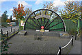
Calverton Colliery memorial
The colliery operated between 1952 and 1999.
Image: © Bill Boaden
Taken: 15 Oct 2022
0.13 miles
6
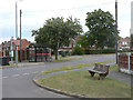
Collyer Road at Lee Road
The design of bench seat with the large baulk of timber at the back of the seat seems to be a specific local variant.
Image: © Alan Murray-Rust
Taken: 14 Aug 2011
0.13 miles
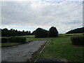
7
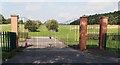
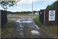
Hollinwood Lane, Calverton, Notts.
A set of gates leading towards an avenue of low trees or bushes in an otherwise unused field. This field has remained untouched for several years and there is no indication as to why the entrance was created. It sits a 50 metres or so along this cul-de-sac that provides access - on the photographer's right - to a Gedling Council Recycling Centre (a.k.a "a local tip"), to the Calverton Miners' Welfare Club, a new housing development and a small number of older houses.
Image: © David Hallam-Jones
Taken: 1 Oct 2015
0.14 miles
8
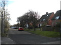
North Green, Calverton
A residential cul de sac separate from the rest of the village, near the site of the colliery.
Image: © Richard Vince
Taken: 2 Dec 2017
0.15 miles
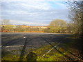
9
Former sports ground off Hollinwood Lane
Image: © Jonathan Thacker
Taken: 17 Sep 2021
0.16 miles
10
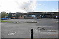
Disused car park off North Green, Calverton
Very close to the site of Calverton Colliery, which it presumably served.
Image: © Richard Vince
Taken: 2 Dec 2017
0.16 miles