IMAGES TAKEN NEAR TO
Moor Lane, NOTTINGHAM, NG14 6QU
Introduction
This page details the photographs taken nearby to Moor Lane, NG14 6QU by members of the Geograph project.
The Geograph project started in 2005 with the aim of publishing, organising and preserving representative images for every square kilometre of Great Britain, Ireland and the Isle of Man.

There are currently over 7.5m images from over14,400 individuals and you can help contribute to the project by visiting https://www.geograph.org.uk
Image Map
Images are licensed for reuse under creativecommons.org/licenses/by-sa/2.0
Notes
- Clicking on the map will re-center to the selected point.
- The higher the marker number, the further away the image location is from the centre of the postcode.
Image Listing (8 Images Found)
Images are licensed for reuse under creativecommons.org/licenses/by-sa/2.0
Image
Details
Distance
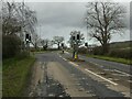
3
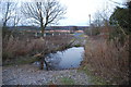
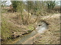
Ford over the Dover Beck, Calverton
This ford is found beside the fish farm just off the road out of Calverton as it approaches the junction with the A6097.
Image: © John Walton
Taken: 26 Feb 2012
0.14 miles
5
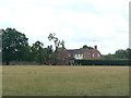
Spring Hill Farm
No longer an active farm.
Image: © Alan Murray-Rust
Taken: 14 Aug 2011
0.22 miles
7
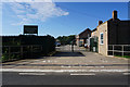
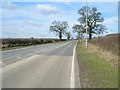
Junction of Epperstone Bypass and Moor Lane
Moor Lane Leads to Calverton Village
Image: © Tom Courtney
Taken: 17 Aug 2005
0.24 miles
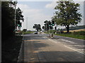
8
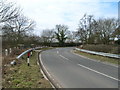
Junction of Epperstone Bypass and Moor Lane
Recreating this 'First' for the square https://www.geograph.org.uk/photo/38996 . I was careful to wait for a lull in the traffic before stepping out into the roadway for the picture!
Image: © Alan Murray-Rust
Taken: 1 Jan 2023
0.24 miles