IMAGES TAKEN NEAR TO
Moor Lane, NOTTINGHAM, NG14 6QS
Introduction
This page details the photographs taken nearby to Moor Lane, NG14 6QS by members of the Geograph project.
The Geograph project started in 2005 with the aim of publishing, organising and preserving representative images for every square kilometre of Great Britain, Ireland and the Isle of Man.

There are currently over 7.5m images from over14,400 individuals and you can help contribute to the project by visiting https://www.geograph.org.uk
Image Map
Images are licensed for reuse under creativecommons.org/licenses/by-sa/2.0
Notes
- Clicking on the map will re-center to the selected point.
- The higher the marker number, the further away the image location is from the centre of the postcode.
Image Listing (9 Images Found)
Images are licensed for reuse under creativecommons.org/licenses/by-sa/2.0
Image
Details
Distance
2
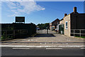
Spring Hill Farm
No longer an active farm.
Image: © Alan Murray-Rust
Taken: 14 Aug 2011
0.15 miles
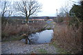
4
Dover Beck Valley
Looking across from near Calverton sewage works to Epperstone Park.
Image: © Alan Murray-Rust
Taken: 14 Aug 2011
0.19 miles
5
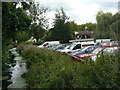
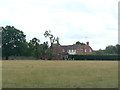
Springwater Golf Club
Clubhouse and car park, with the Grimesmoor Dyke stream to the left.
Image: © Alan Murray-Rust
Taken: 14 Aug 2011
0.20 miles
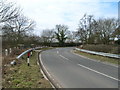
7
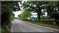
Ford over the Dover Beck, Calverton
This ford is found beside the fish farm just off the road out of Calverton as it approaches the junction with the A6097.
Image: © John Walton
Taken: 26 Feb 2012
0.21 miles
8
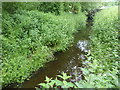
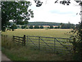
Grimesmoor Dyke
A field drain that after 5 miles drains into the River Trent
Image: © Graham Hogg
Taken: 5 Jun 2018
0.23 miles
9
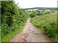
Way on down
Rough track between Woodborough and Calverton
Image: © cris sloan
Taken: 4 Jul 2007
0.23 miles