1
Weird Gourds
Left out to dry on an old bath tub at the village allotments.
Image: © Patrick Mackie
Taken: 11 Feb 2007
0.03 miles
2
Calverton House
A former vicarage https://historicengland.org.uk/listing/the-list/list-entry/1227469
Image: © Jonathan Thacker
Taken: 17 Sep 2021
0.09 miles
3
18 Main Street, Calverton
The greater part dates from the late eighteenth century https://historicengland.org.uk/listing/the-list/list-entry/1264854
Image: © Jonathan Thacker
Taken: 17 Sep 2021
0.09 miles
4
14 and 16 Main Street, Calverton
Early eighteenth century house now divided into two https://historicengland.org.uk/listing/the-list/list-entry/1227471
Image: © Jonathan Thacker
Taken: 17 Sep 2021
0.09 miles
5
Main Street, Calverton
Looking west from the junction with Bonner Hill.
Image: © Alan Murray-Rust
Taken: 14 Aug 2011
0.09 miles
6
Main Street, looking east from Burnor Pool
To the left are nos.18 (nearer) and 14/16 (whitewashed). No.18 was originally two dwellings and dates from late 18th to late 19th centuries. Nos.14/16 date from early 18 and mid 19th centuries. All are Listed Grade II.
Image: © Alan Murray-Rust
Taken: 14 Aug 2011
0.10 miles
7
St Wilfrid's Church
Although dating from the late 13th/14th century, the nave and tower were largely rebuilt in 1763; the chancel was rebuilt in 1835 and the church again restored in 1881. The porch is of this period too. Note the use of spreaders in the form of a cross for the strengthening ties across the church. Listed Grade II*.
Image: © Alan Murray-Rust
Taken: 14 Aug 2011
0.10 miles
8
Church of St Wilfrid, Calverton
Although 13th century in origin, the external aspect is largely the result of major rebuilding, including the tower, in 1760-3. The Gothic windows were formed during the restoration of 1881, replacing round headed windows in style matching those of the tower. Listed Grade II*.
Image: © Alan Murray-Rust
Taken: 18 Jan 2023
0.10 miles
9
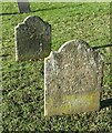
Gravestones in the churchyard of St Wilfrid's Calverton
The further one is dated 1707 and will be among the earliest stones in the churchyard. It commemorates ?Catherine daughter of Thomas and Mary ?Lee who died 2?5th August 1707 at the age of just eleven weeks. It represents a substantial investment to commemorate an infant child.
Image: © Alan Murray-Rust
Taken: 18 Jan 2023
0.10 miles
10
Church of St Wilfrid, Calverton
The west tower, rebuilt 1760-3 in Georgian ('James Gibbs rusticated') style, reusing the original Norman masonry. Listed Grade II*.
Image: © Alan Murray-Rust
Taken: 18 Jan 2023
0.10 miles


