IMAGES TAKEN NEAR TO
Woods Lane, NOTTINGHAM, NG14 6FF
Introduction
This page details the photographs taken nearby to Woods Lane, NG14 6FF by members of the Geograph project.
The Geograph project started in 2005 with the aim of publishing, organising and preserving representative images for every square kilometre of Great Britain, Ireland and the Isle of Man.

There are currently over 7.5m images from over14,400 individuals and you can help contribute to the project by visiting https://www.geograph.org.uk
Image Map
Images are licensed for reuse under creativecommons.org/licenses/by-sa/2.0
Notes
- Clicking on the map will re-center to the selected point.
- The higher the marker number, the further away the image location is from the centre of the postcode.
Image Listing (71 Images Found)
Images are licensed for reuse under creativecommons.org/licenses/by-sa/2.0
Image
Details
Distance
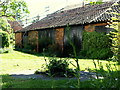
1
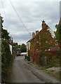
Woods Lane
A narrow field access lane off Main Street, with a fine display of Virginia Creeper.
Image: © Alan Murray-Rust
Taken: 14 Aug 2011
0.01 miles
2
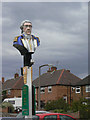
Admiral Rodney
A distinctive inn sign, it may bear little resemblance to the man himself.
Image: © Alan Murray-Rust
Taken: 14 Aug 2011
0.01 miles
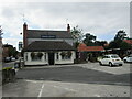
3
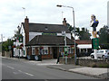
Admiral Rodney pub
One of three public houses along Main Street, with its distinctive inn sign.
Image: © Alan Murray-Rust
Taken: 14 Aug 2011
0.02 miles
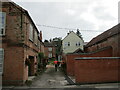
4
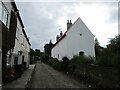
Woods Lane, Calverton
A public footpath. The house on the right is listed https://historicengland.org.uk/listing/the-list/list-entry/1227475
Image: © Jonathan Thacker
Taken: 17 Sep 2021
0.02 miles
6
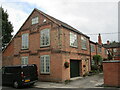
Former factory buildings, Main Street, Calverton
Now housing.
Image: © Jonathan Thacker
Taken: 17 Sep 2021
0.03 miles
8
Calverton NG14, Notts.
The former forge at 135, Main Street, with the concrete circle on the grass that was used by the blacksmith to apply the thin iron bands to his wooden cart wheels.
Image: © David Hallam-Jones
Taken: 26 May 2013
0.03 miles
9
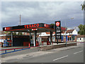
Manor Fuel Service Station
The village is large enough to support a major chain filling station.
Image: © Alan Murray-Rust
Taken: 14 Aug 2011
0.04 miles
10
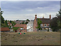
145 Main Street
The barns beyond the house indicate that it would originally have been a farm, although it is not named on earlier mapping.
Image: © Alan Murray-Rust
Taken: 14 Aug 2011
0.05 miles