IMAGES TAKEN NEAR TO
Holme Close, NOTTINGHAM, NG14 6EX
Introduction
This page details the photographs taken nearby to Holme Close, NG14 6EX by members of the Geograph project.
The Geograph project started in 2005 with the aim of publishing, organising and preserving representative images for every square kilometre of Great Britain, Ireland and the Isle of Man.

There are currently over 7.5m images from over14,400 individuals and you can help contribute to the project by visiting https://www.geograph.org.uk
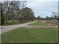
Image Map
Images are licensed for reuse under creativecommons.org/licenses/by-sa/2.0
Notes
- Clicking on the map will re-center to the selected point.
- The higher the marker number, the further away the image location is from the centre of the postcode.
Image Listing (41 Images Found)
Images are licensed for reuse under creativecommons.org/licenses/by-sa/2.0
Image
Details
Distance
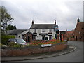
1
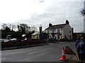
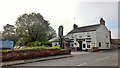
Nag's Head, Woodborough
Filling up nicely at lunchtime, and the ubiquitous road works sign.
Image: © Peter Barr
Taken: 9 Mar 2010
0.06 miles
2
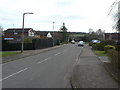
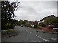
Small's Croft
1970s residential development, part of the expansion of Woodborough as a commuter dormitory for Nottingham.
Image: © Alan Murray-Rust
Taken: 20 Mar 2011
0.06 miles
3
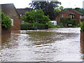
Woodborough Main Street
Flash floods when heavy rain caused the Dover Beck to overflow June 2007
Image: © lynne cater
Taken: 25 Jun 2007
0.07 miles
4
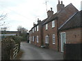
Cottages off Main Street
A group of three early 19th century cottages, of which the nearer two have been merged at some time. Listed Grade II.
Image: © Alan Murray-Rust
Taken: 20 Mar 2011
0.08 miles
5
Small's Croft, Woodborough
Off Main Street near the east end of the village.
Image: © Richard Vince
Taken: 25 Oct 2014
0.09 miles
6
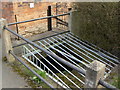
Grill above Main Street Dyke
Following the severe floods in June/July 2007 http://www.geograph.org.uk/photo/483720 , steps have been taken to ensure that this culverted stream is kept clear of debris, a contributing factor to those floods.
Image: © Alan Murray-Rust
Taken: 20 Mar 2011
0.09 miles
8
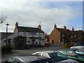
The Nag's Head
One of two surviving public houses in the village. There were formerly seven.
Image: © Alan Murray-Rust
Taken: 20 Mar 2011
0.10 miles
9
Drive to Manor Farm
This stretch is also designated as a bridleway.
Image: © Alan Murray-Rust
Taken: 20 Mar 2011
0.10 miles
10
The Nags Head, Woodborough
Do any pubs with this name retain the apostrophe?
Image: © Richard Vince
Taken: 25 Oct 2014
0.10 miles