IMAGES TAKEN NEAR TO
Epperstone By Pass, NOTTINGHAM, NG14 6DH
Introduction
This page details the photographs taken nearby to Epperstone By Pass, NG14 6DH by members of the Geograph project.
The Geograph project started in 2005 with the aim of publishing, organising and preserving representative images for every square kilometre of Great Britain, Ireland and the Isle of Man.

There are currently over 7.5m images from over14,400 individuals and you can help contribute to the project by visiting https://www.geograph.org.uk
Image Map
Images are licensed for reuse under creativecommons.org/licenses/by-sa/2.0
Notes
- Clicking on the map will re-center to the selected point.
- The higher the marker number, the further away the image location is from the centre of the postcode.
Image Listing (20 Images Found)
Images are licensed for reuse under creativecommons.org/licenses/by-sa/2.0
Image
Details
Distance
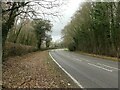
1
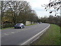
Epperstone bypass
This dates back to the interwar period and was part of the new link between the A46 and the A1 under the unemployment relief program of the late 1920s.
Image: © Alan Murray-Rust
Taken: 20 Mar 2011
0.05 miles
2
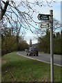
Epperstone bypass
Standard Nottinghamshire footpath fingerpost of the metal post variety.
Image: © Alan Murray-Rust
Taken: 20 Mar 2011
0.06 miles
3
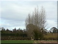
Poplar windbreak
Close to the former Woodborough Mill
Image: © Alan Murray-Rust
Taken: 20 Mar 2011
0.07 miles
4
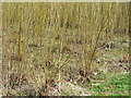
Coppiced willow
Although relatively young, these willows show that they have already been coppiced at least once, and are now growing again. The size of the cut with stems no more than 30-40mm in diameter suggests that that it may be being chipped for fuel.
Image: © Alan Murray-Rust
Taken: 20 Mar 2011
0.08 miles
5
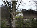
Topping fence
Osier screening with a bit of twine, supported by tree
Image: © Peter Barr
Taken: 9 Mar 2010
0.09 miles
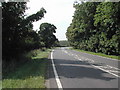
6
Epperstone Bypass, A6097
Recreating this 'First' for the square https://www.geograph.org.uk/photo/38986 . Even on New Year's Day I had to be patient to get a view without any vehicles.
Image: © Alan Murray-Rust
Taken: 1 Jan 2023
0.12 miles
9
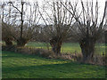
Pollarded willows
Alongside a drainage channel in the meadows along the Dover Beck.
Image: © Alan Murray-Rust
Taken: 18 Dec 2009
0.18 miles
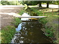
10
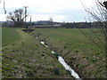
Woodborough Dyke
This innocuous-looking stream nevertheless flooded with considerable damage to properties in the village in 2007 following prolonged heavy rain http://www.geograph.org.uk/photo/483720.
Image: © Alan Murray-Rust
Taken: 20 Mar 2011
0.20 miles