IMAGES TAKEN NEAR TO
Epperstone, NOTTINGHAM, NG14 6AR
Introduction
This page details the photographs taken nearby to NG14 6AR by members of the Geograph project.
The Geograph project started in 2005 with the aim of publishing, organising and preserving representative images for every square kilometre of Great Britain, Ireland and the Isle of Man.

There are currently over 7.5m images from over14,400 individuals and you can help contribute to the project by visiting https://www.geograph.org.uk
Image Map
Images are licensed for reuse under creativecommons.org/licenses/by-sa/2.0
Notes
- Clicking on the map will re-center to the selected point.
- The higher the marker number, the further away the image location is from the centre of the postcode.
Image Listing (2 Images Found)
Images are licensed for reuse under creativecommons.org/licenses/by-sa/2.0
Image
Details
Distance
1
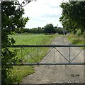
Lane to Ricketwood Farm
Local agriculture has been consolidated around a small number of the original farms; this is one of them.
Image: © Alan Murray-Rust
Taken: 12 Jul 2020
0.18 miles
2
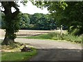
Bend in the track
The public bridleway follows the track, as indicated by the fingerpost.
Image: © Alan Murray-Rust
Taken: 12 Jul 2020
0.22 miles