IMAGES TAKEN NEAR TO
Carnarvon Drive, NOTTINGHAM, NG14 5ER
Introduction
This page details the photographs taken nearby to Carnarvon Drive, NG14 5ER by members of the Geograph project.
The Geograph project started in 2005 with the aim of publishing, organising and preserving representative images for every square kilometre of Great Britain, Ireland and the Isle of Man.

There are currently over 7.5m images from over14,400 individuals and you can help contribute to the project by visiting https://www.geograph.org.uk
Image Map
Images are licensed for reuse under creativecommons.org/licenses/by-sa/2.0
Notes
- Clicking on the map will re-center to the selected point.
- The higher the marker number, the further away the image location is from the centre of the postcode.
Image Listing (102 Images Found)
Images are licensed for reuse under creativecommons.org/licenses/by-sa/2.0
Image
Details
Distance
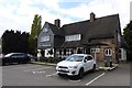
1
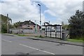
Vacant plot
Set for a pair of semi-detached houses. Until recently a carpenter's workshop. The land site was sold as the last of a line of family owners of the business died (according to a passing local out walking her dog).
There is a picture of the old sheds here Image
Image: © David Lally
Taken: 17 Apr 2017
0.04 miles
2
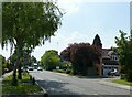
Church Road, Burton Joyce
Recreating this 'First' for the square http://www.geograph.org.uk/photo/35710
Image: © Alan Murray-Rust
Taken: 1 Jun 2021
0.05 miles
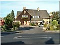
5
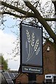
The sign of The Wheatsheaf
This is at the rear entrance off Main Street.
Image: © David Lally
Taken: 17 Apr 2017
0.05 miles
6
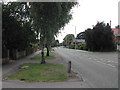
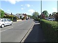
Church Road, Burton Joyce
This is a small village between Carlton and Lowdham
Image: © Tom Courtney
Taken: 9 Aug 2005
0.05 miles
9
Main St. from outside the Methodist Church
Image: © johnfromnotts
Taken: 24 May 2009
0.06 miles
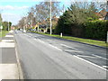
10
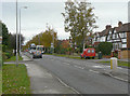
Church Road, Burton Joyce
This road was driven through the village in the tween wars period to reduce traffic through the old twisty and narrow Main Street. The housing style is very much of the period.
Image: © Alan Murray-Rust
Taken: 14 Nov 2008
0.07 miles