IMAGES TAKEN NEAR TO
Brusty Place, NOTTINGHAM, NG14 5BY
Introduction
This page details the photographs taken nearby to Brusty Place, NG14 5BY by members of the Geograph project.
The Geograph project started in 2005 with the aim of publishing, organising and preserving representative images for every square kilometre of Great Britain, Ireland and the Isle of Man.

There are currently over 7.5m images from over14,400 individuals and you can help contribute to the project by visiting https://www.geograph.org.uk
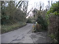
Image Map
Images are licensed for reuse under creativecommons.org/licenses/by-sa/2.0
Notes
- Clicking on the map will re-center to the selected point.
- The higher the marker number, the further away the image location is from the centre of the postcode.
Image Listing (47 Images Found)
Images are licensed for reuse under creativecommons.org/licenses/by-sa/2.0
Image
Details
Distance
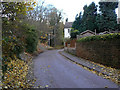
1
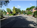
Padleys Lane junction with Covert Close
Image: © johnfromnotts
Taken: 11 May 2009
0.05 miles
2
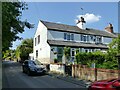
Rose Cottages
Recreating this 'First' for the square http://www.geograph.org.uk/photo/43275 .
This row of cottages was originally called Top Row and was built with framework knitters' workshops at a time when that was become a widespread local home-work industry.
Image: © Alan Murray-Rust
Taken: 1 Jun 2021
0.05 miles
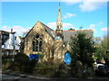
3
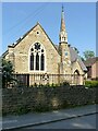
Former Congregational Church, Burton Joyce
Built in 1869, the delicate spire is a particularly attractive feature. Now a private residence.
Image: © Alan Murray-Rust
Taken: 1 Jun 2021
0.08 miles
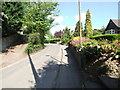
5
Lambley Lane
An old thoroughfare to the neighbouring village of Lambley, it is shown as a restricted byway, although in practice it is the access to a substantial area of residential properties.
Image: © Alan Murray-Rust
Taken: 14 Nov 2008
0.09 miles
6
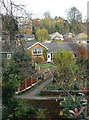
Crock Dumble
View across the dumble from Lambley Lane. This part of the valley has been built up with homes for Nottingham commuters. At the foot of the picture is the bridge carrying Bridle Road over the dumble stream.
Image: © Alan Murray-Rust
Taken: 14 Nov 2008
0.09 miles
8
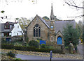
United Reformed Church
On Lambley Lane, this was formerly a Congregational chapel.
Image: © Alan Murray-Rust
Taken: 14 Nov 2008
0.09 miles
9
South end of Bridle Road, Burton Joyce
Where Bridle Road (right) meets Lambley Lane. Perhaps "Road" and "Lane" should be transposed.
Image: © Richard Vince
Taken: 22 Feb 2014
0.09 miles
10
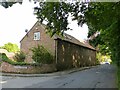
1 & 25 Elmsdale Gardens
Former barn, late 17th century timber frame, re-cased in brick in 1751, converted to residential use late 20th century. Listed Grade II.
Image: © Alan Murray-Rust
Taken: 1 Jun 2021
0.10 miles