IMAGES TAKEN NEAR TO
Lambley Lane, NOTTINGHAM, NG14 5BP
Introduction
This page details the photographs taken nearby to Lambley Lane, NG14 5BP by members of the Geograph project.
The Geograph project started in 2005 with the aim of publishing, organising and preserving representative images for every square kilometre of Great Britain, Ireland and the Isle of Man.

There are currently over 7.5m images from over14,400 individuals and you can help contribute to the project by visiting https://www.geograph.org.uk
Image Map
Images are licensed for reuse under creativecommons.org/licenses/by-sa/2.0
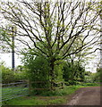
Notes
- Clicking on the map will re-center to the selected point.
- The higher the marker number, the further away the image location is from the centre of the postcode.
Image Listing (21 Images Found)
Images are licensed for reuse under creativecommons.org/licenses/by-sa/2.0
Image
Details
Distance
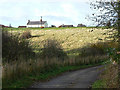
1
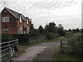
Stockhill Farm
on the bridle path between Lambley and Burton Joyce
Image: © Tom Courtney
Taken: 26 Aug 2005
0.01 miles
2
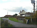
Lodge Farm
On the top of the hill between Burton Joyce and Lambley.
Image: © Alan Murray-Rust
Taken: 14 Nov 2008
0.02 miles
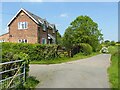
3
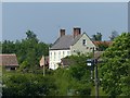
Lodge Farm, Burton Joyce
Formerly known as Burton Lodge. Late 17th century farmhouse, Listed Grade II. The building underwent a significant renovation in the early 21st century.
Image: © Alan Murray-Rust
Taken: 20 May 2020
0.02 miles
4
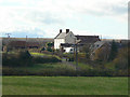
Lodge Farm
Seen from the top of Bridle Road. The farmhouse looks to be late 18th or early 19th century.
Image: © Alan Murray-Rust
Taken: 14 Nov 2008
0.03 miles
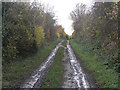
5
Lambley Lane
At this point the lane has properly become a restricted byway, serving the farm on the top of the hill.
Image: © Alan Murray-Rust
Taken: 14 Nov 2008
0.04 miles
6
Stockhill Farm
Recreating this 'First' for the square http://www.geograph.org.uk/photo/43273
Image: © Alan Murray-Rust
Taken: 1 Jun 2021
0.06 miles
7
Bridleway towards Mapperley
This joins the road out of Lambley at the top of Wicketwood Hill.
Image: © Alan Murray-Rust
Taken: 14 Nov 2008
0.08 miles
8
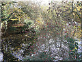
Marl pond
The result of excavating the marl (clay) for spreading on the fields as fertiliser. Many of these ponds are sited in field boundaries so that the clay could be carried either way, and also because they provided water for grazing animals.
Image: © Alan Murray-Rust
Taken: 14 Nov 2008
0.08 miles
9
Stockhill Farm Area, NG14, Notts.
A section of a bridleway and footpath near Stockhill Farm (on the right, round the bend). The other end of this track is on Spring Lane, behind the photographer, near Wood Farm. A notice on the security fencing that surrounds this transmitter identifies it as being operated by "Orange UK"
Image: © David Hallam-Jones
Taken: 12 May 2013
0.09 miles
10
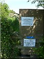
Footpath closure, Covid-19
“This path passes through a private garden/working farmyard/working stables”. Not obviously so from maps/satellite images, but the alternative is in practice an easier route. The notice is clearly an NFU standard notice, as the alternative route is via existing rights of way rather than permissive paths as the notice implies.
Image: © Alan Murray-Rust
Taken: 20 May 2020
0.09 miles