IMAGES TAKEN NEAR TO
Huntingdon Street, NOTTINGHAM, NG1 3NX
Introduction
This page details the photographs taken nearby to Huntingdon Street, NG1 3NX by members of the Geograph project.
The Geograph project started in 2005 with the aim of publishing, organising and preserving representative images for every square kilometre of Great Britain, Ireland and the Isle of Man.

There are currently over 7.5m images from over14,400 individuals and you can help contribute to the project by visiting https://www.geograph.org.uk
Image Map
Images are licensed for reuse under creativecommons.org/licenses/by-sa/2.0
Notes
- Clicking on the map will re-center to the selected point.
- The higher the marker number, the further away the image location is from the centre of the postcode.
Image Listing (600 Images Found)
Images are licensed for reuse under creativecommons.org/licenses/by-sa/2.0
Image
Details
Distance
1
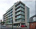
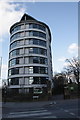
Litmus, King Edward Street, Nottingham
Le Corbusier lives on in CPMG's flats of 2004-08.
Image: © Stephen Richards
Taken: 19 Jun 2015
0.01 miles
2
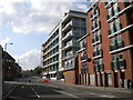
Huntingdon Street near King Edward Street
The Litmus building (centre) occupies a prominent position on Huntingdon Street just north of King Edward Street, while another modern block of flats (right foreground) looms over the Salvation Army citadel. I was able to take this picture from the middle of this normally busy road because it was closed due to the Olympic torch relay.
Image: © Richard Vince
Taken: 28 Jun 2012
0.02 miles
3
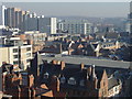
View from the Eye (1)
Looking east-northeast with the Victoria Centre flats to the left and the high ground of Mapperley in the distance.
For views from the Nottingham Eye see http://www.geograph.org.uk/search.php?i=2274643 . To add your views to the slide show, simply ensure that the title or description includes 'View from the Eye.
Image: © Alan Murray-Rust
Taken: 17 Feb 2008
0.03 miles
4
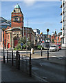
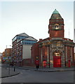
The William Booth Memorial Halls and King Edward Street
A view past the Salvation Army halls (named after the Army's founder, a Nottinghamian) from the bottom of St Ann's Well Road. King Edward Street leads to Parliament Street and the newish red-brick buildings to the right are on the site of the old Central Market. The dome of the Council House shows on the skyline to the right.
Image: © John Sutton
Taken: 16 Aug 2016
0.03 miles
5

King Edward Street, Hockley, Nottingham
The Depot Rock Climbing Centre opened in October 2012. It is housed in a former power station built 1901-02 and designed by the city engineer, Arthur Brown.
Image: © David Hallam-Jones
Taken: 10 Jan 2015
0.03 miles
6
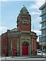
William Booth Memorial Hall, King Edward Street, Nottingham
By Oswald Archer, 1914-15. Quite a grand Baroque doorway, the tower above which is rather under-sized.
Still in use by the Salvation Army.
Image: © Stephen Richards
Taken: 18 Jun 2012
0.04 miles
7
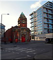
Roundabout near Beck Street, Hockley, Nottingham
Several of the entrances into The William Booth Memorial Halls. This citadel is situated on a plot of land between King Edward Street - on the right - and Beck Street on the left. The Litmus Building, whose entrance is on Huntingdon Street, is a residential block of privately owned apartments.
Image: © David Hallam-Jones
Taken: 10 Jan 2015
0.04 miles
8
Salvation Army citadel, King Edward Street, Nottingham
Another contributor Image gives the date as 1915 and the architect as Oswald Archer.
Image: © Stephen Craven
Taken: 18 Jan 2020
0.04 miles
9
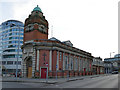
Beck Street, Hockley, Nottingham
A side elevation of The William Booth Memorial Halls on Beck Street, with Huntingdon Street in the distance.
Image: © David Hallam-Jones
Taken: 10 Jan 2015
0.04 miles
10
Victoria Hall, Bath Street
There is an OS benchmark Image on the right hand gatepost of the entrance to St Mary's Rest Garden, to the right of Victoria Hall which is student accommodation
Image: © Roger Templeman
Taken: 30 Mar 2013
0.05 miles