IMAGES TAKEN NEAR TO
Convent Street, NOTTINGHAM, NG1 3LL
Introduction
This page details the photographs taken nearby to Convent Street, NG1 3LL by members of the Geograph project.
The Geograph project started in 2005 with the aim of publishing, organising and preserving representative images for every square kilometre of Great Britain, Ireland and the Isle of Man.

There are currently over 7.5m images from over14,400 individuals and you can help contribute to the project by visiting https://www.geograph.org.uk
Image Map
Images are licensed for reuse under creativecommons.org/licenses/by-sa/2.0
Notes
- Clicking on the map will re-center to the selected point.
- The higher the marker number, the further away the image location is from the centre of the postcode.
Image Listing (882 Images Found)
Images are licensed for reuse under creativecommons.org/licenses/by-sa/2.0
Image
Details
Distance
1
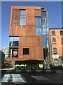
Confetti Institute of Creative Technologies, Convent Street
Image: © Bryn Holmes
Taken: 26 Feb 2019
0.02 miles
2
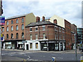
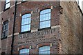
Corner of Beck Street
The corner building is enclosed by what was once a lace factory. There were many of this sort of industrial building very close to the city centre like this one.
Image: © Alan Murray-Rust
Taken: 17 Jun 2008
0.02 miles
3
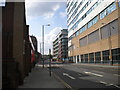
King Edward Street/A60, Nottingham city centre
Image: © Bryn Holmes
Taken: 16 Mar 2020
0.03 miles
4
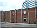
Filling station
The title is not wrong - it is the back wall of a filling station on the neighbouring street. The round-headed openings reflect the style of many of the small lace factories formerly found in this part of the city.
Image: © Alan Murray-Rust
Taken: 17 Jun 2008
0.03 miles
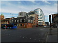
5
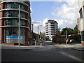
Concrete canyon, Huntingdon Street
Looking north from very near the bottom of Huntingdon Street. The scene is dominated by Marco Island (right) and the Litmus building (centre).
Image: © Richard Vince
Taken: 28 Jun 2012
0.03 miles
6
Pryzm nightclub, Lower Parliament Street
Image: © Bryn Holmes
Taken: 19 Sep 2018
0.04 miles
7

'Fierce' Camper Van
Decorated camper van
Image: © Adam Jackson
Taken: 3 Jun 2010
0.04 miles
8
Beck Street (north)
The northern half of Beck Street, seen from Huntingdon Street.
Image: © Richard Vince
Taken: 28 Jun 2012
0.05 miles
9
Fading painted sign
The frontage of this building on Lower Parliament Street appears to have been sliced-through. The sign actually looks quite recent with an austere font.
Image: © David Lally
Taken: 14 Nov 2009
0.05 miles
10
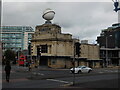
Nottingham - NG1
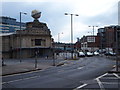
Wedged between Huntingdon St (A60), off to the left and Lower Parliament St (A6008) straight ahead, is the Oceana nightclub in the Hockley neighbourhood of Nottingham city centre. Opened in 1925 as the Palais de Dance with a billiard saloon, it was constructed of Weldon stone in a ‘Classic’ architectural style on the site of a former House of Correction. Apparently its globe used to flash red, white and blue until objections were raised by the management of East Midlands Airport. In the 1980's it became 'The Ritzy'.However its former title and its iconic globe were eventually restored in 2001.
Image: © David Hallam-Jones
Taken: 21 Apr 2012
0.05 miles