IMAGES TAKEN NEAR TO
Mansfield Road, NOTTINGHAM, NG1 3FT
Introduction
This page details the photographs taken nearby to Mansfield Road, NG1 3FT by members of the Geograph project.
The Geograph project started in 2005 with the aim of publishing, organising and preserving representative images for every square kilometre of Great Britain, Ireland and the Isle of Man.

There are currently over 7.5m images from over14,400 individuals and you can help contribute to the project by visiting https://www.geograph.org.uk
Image Map
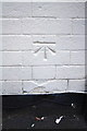
Images are licensed for reuse under creativecommons.org/licenses/by-sa/2.0
Notes
- Clicking on the map will re-center to the selected point.
- The higher the marker number, the further away the image location is from the centre of the postcode.
Image Listing (346 Images Found)
Images are licensed for reuse under creativecommons.org/licenses/by-sa/2.0
Image
Details
Distance
1
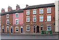
Nottingham - Mansfield Road (around No 243)
For a further views of Mansfield Road in this area, please see Alan Murray-Rust's set of photos, starting at Image
Image: © Dave Bevis
Taken: 25 Feb 2013
0.00 miles
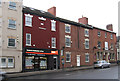
2

Forest Tavern/ The Maze, Nottingham
Forest tavern is a public house attached to the Maze, a live music venue.
Image: © Chris Whippet
Taken: 28 Jul 2015
0.01 miles
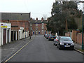
3
Nottingham - Mansfield Road (around The Maze pub)
For a further views of Mansfield Road in this area, please see Alan Murray-Rust's set of photos, starting at Image
Image: © Dave Bevis
Taken: 25 Feb 2013
0.01 miles
4
![Three religions [1]](https://s0.geograph.org.uk/geophotos/05/34/90/5349080_ecb9ca3d_120x120.jpg)
Three religions [1]
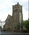
Built in 1896 as a Presbyterian church, later a Christian Scientist church.
Now, since 2012, a Sikh Gurdwara. The gurdwara provides a place of worship, education and other religious services according to the rites of the Guru Granth Sahib Ji (the central religious text of Sikhism).
The church and boundary wall is listed, grade II, with details at: https://www.historicengland.org.uk/listing/the-list/list-entry/1254767
Image: © Michael Dibb
Taken: 31 Mar 2017
0.02 miles
5
Villa Road
Looking towards Mansfield Road. This is the opposite direction to Image and there is a stark contrast between the type of housing at the opposite ends.
Image: © Alan Murray-Rust
Taken: 8 Mar 2009
0.02 miles
6
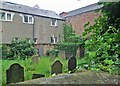
Jewish Cemetery, North Sherwood Street
This was the camera's view but not mine as I held it at arm's length and pointed it over the high Bulwell stone wall shown in David Hallam-Jones's Image The cemetery was in use from 1882-9.
Image: © John Sutton
Taken: 23 Jun 2013
0.02 miles
7
Benchmark on #252 North Sherwood Road
Ordnance Survey cut mark benchmark described on the Bench Mark Database at http://www.bench-marks.org.uk/bm47853
Image: © Roger Templeman
Taken: 30 Mar 2013
0.02 miles
8
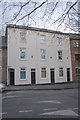
White-painted houses on North Sherwood Street
There is an OS benchmark Image on the wall to the right of the left hand door
Image: © Roger Templeman
Taken: 30 Mar 2013
0.02 miles
9
Raja Sahib II Gurdwara, Mansfield Road, Nottingham
The church has seen a variety of religious persuasions in its lifetime. Built 1896 by Brewill & Baily of Nottingham in an Art-Nouveau influenced Perpendicular style. Listed Grade II, the Listing includes the boundary wall and gateway. Taken over from the Presbyterian Church by the Christian Science Church, in the early 21st century it took on a third life as a Hindu gurdwara.
Image: © Alan Murray-Rust
Taken: 12 Aug 2019
0.02 miles
10
![Three religions [2]](https://s1.geograph.org.uk/geophotos/05/34/90/5349081_d920d316_120x120.jpg)
Three religions [2]
Built in 1896 as a Presbyterian church, later a Christian Scientist church.
Now, since 2012, a Sikh Gurdwara. The gurdwara provides a place of worship, education and other religious services according to the rites of the Guru Granth Sahib Ji (the central religious text of Sikhism).
The church and boundary wall is listed, grade II, with details at: https://www.historicengland.org.uk/listing/the-list/list-entry/1254767
Image: © Michael Dibb
Taken: 31 Mar 2017
0.02 miles