IMAGES TAKEN NEAR TO
Mansfield Road, NOTTINGHAM, NG1 3FH
Introduction
This page details the photographs taken nearby to Mansfield Road, NG1 3FH by members of the Geograph project.
The Geograph project started in 2005 with the aim of publishing, organising and preserving representative images for every square kilometre of Great Britain, Ireland and the Isle of Man.

There are currently over 7.5m images from over14,400 individuals and you can help contribute to the project by visiting https://www.geograph.org.uk
Image Map
Images are licensed for reuse under creativecommons.org/licenses/by-sa/2.0
Notes
- Clicking on the map will re-center to the selected point.
- The higher the marker number, the further away the image location is from the centre of the postcode.
Image Listing (374 Images Found)
Images are licensed for reuse under creativecommons.org/licenses/by-sa/2.0
Image
Details
Distance
1
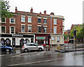
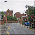
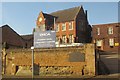
Mansfield Road on a wet morning
Encounters Restaurant occupies a former baker's shop, C W Judge. Cars are waiting at the Woodborough Road lights.
Image: © John Sutton
Taken: 11 Sep 2018
0.00 miles
2
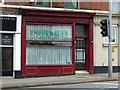
Former C W Judge bakery, Mansfield Road, Nottingham
See http://www.geograph.org.uk/photo/6225183 for location. The original shop front of c.1860 survives intact.
Image: © Alan Murray-Rust
Taken: 26 Jul 2019
0.01 miles
3
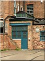
Refreshment room at the rear of the former Judge's bakery
The rear of the building described in this view https://www.geograph.org.uk/photo/6225183 .
The refreshment room was added in c.1900, with an unusual clerestory roof and elaborate stained glass windows. Listed Grade II.
Image: © Alan Murray-Rust
Taken: 12 Aug 2019
0.01 miles
4
Former C W Judge bakery, Mansfield Road, Nottingham
The second building from the corner. Built c.1860, Listed Grade II for the survival of many of the original bakery features in the basement and the cafe extension to the rear. Until recently occupied by a restaurant.
Image: © Alan Murray-Rust
Taken: 26 Jul 2019
0.01 miles
5
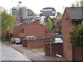
Up Bluecoat Close
The tall building to the left is the former Bluecoat School. The building in the centre middle distance is a many-windowed former lace or hosiery works. Apart from the bright rowan berries, colours were muted on a damp September morning.
Image: © John Sutton
Taken: 11 Sep 2018
0.02 miles
6
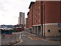
Nottingham - NG1
This view along Bluecoat Close, a cul-de-sac running parallel with Mansfield Road (A60), draws the eye in the direction of a new construction being built on the horizon just beyond the YMCA's city centre building on Shakespeare Street.
Image: © David Hallam-Jones
Taken: 21 Apr 2012
0.02 miles
7
Nottingham - NG1
This is Victoria Bus Station - off the B684 (Woodborough Rd) - with the backs of retail premises and apartments visible on its right-hand side. Although the Victoria Shopping Centre appears to be located immediately in front of a high-rise building in reality the former is not at the foot of the latter, geographically.
Image: © David Hallam-Jones
Taken: 21 Apr 2012
0.02 miles
8
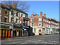
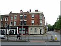
Mansfield Road
Taken to show the distinct change in style and quality on either side of the road junction.
One of a series showing different building styles on Mansfield Road. See http://www.geograph.org.uk/search.php?i=5550541
Image: © Alan Murray-Rust
Taken: 8 Mar 2009
0.02 miles
9
YMCA International Community Centre, Nottingham
Formerly, until 1967, the Nottingham Bluecoat School http://list.english-heritage.org.uk/resultsingle.aspx?uid=1270611&searchtype=mapsearch . It dates from 1852. Note the rock footing to the wall in the foreground.
Image: © Derek Harper
Taken: 12 Oct 2014
0.03 miles
10
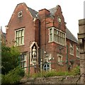
Former Bluecoat School, Mansfield Road, Nottingham
The south east corner of the building, built 1852, by T C Hine, Listed Grade II. Now the YMCA International Community Centre.
Image: © Alan Murray-Rust
Taken: 12 Aug 2019
0.03 miles