IMAGES TAKEN NEAR TO
Kent Street, NOTTINGHAM, NG1 3BW
Introduction
This page details the photographs taken nearby to Kent Street, NG1 3BW by members of the Geograph project.
The Geograph project started in 2005 with the aim of publishing, organising and preserving representative images for every square kilometre of Great Britain, Ireland and the Isle of Man.

There are currently over 7.5m images from over14,400 individuals and you can help contribute to the project by visiting https://www.geograph.org.uk
Image Map
Images are licensed for reuse under creativecommons.org/licenses/by-sa/2.0
Notes
- Clicking on the map will re-center to the selected point.
- The higher the marker number, the further away the image location is from the centre of the postcode.
Image Listing (983 Images Found)
Images are licensed for reuse under creativecommons.org/licenses/by-sa/2.0
Image
Details
Distance
1
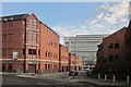
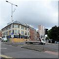
Kent Street, Nottingham
From the junction with Glasshouse Street, the A60 northbound. On the left is Avalon Court, an "office building of concrete frame construction with brick elevations and a tiled roof, set around a courtyard" http://propertylink.estatesgazette.com/property-details/5451371-avalon-court-kent-street-nottingham-nottinghamshire . At the end rises The Litmus Building, flats described as "a distinctive landmark in the Eastside of the city" http://www.premiercitylets.co.uk/key-properties/the-litmus-building .
Image: © Derek Harper
Taken: 11 Oct 2014
0.01 miles
2
On Glasshouse Street
This part of the city has changed out of all recognition in the last fifty years.
Image: © John Sutton
Taken: 15 Apr 2022
0.02 miles
3
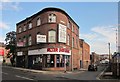
Howard Street, Nottingham
Seen across Glasshouse Street, the A60. The property for sale is a salon and four residential flats. Next door on the right are water heating specialists.
Image: © Derek Harper
Taken: 11 Oct 2014
0.04 miles
4
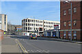
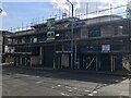
Kent Street, Nottingham city centre
This building is currently being completely renovated into student accommodation.
Image: © Bryn Holmes
Taken: 16 Mar 2020
0.04 miles
5
View from the Eye (1)
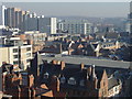
Looking east-northeast with the Victoria Centre flats to the left and the high ground of Mapperley in the distance.
For views from the Nottingham Eye see http://www.geograph.org.uk/search.php?i=2274643 . To add your views to the slide show, simply ensure that the title or description includes 'View from the Eye.
Image: © Alan Murray-Rust
Taken: 17 Feb 2008
0.05 miles
6
At the corner of Glasshouse Street
The tower blocks are part of the Victoria Centre complex. Image] shows work on the building on the left in 2019.
Image: © John Sutton
Taken: 5 Jul 2021
0.05 miles
7
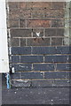
Benchmark on #276 Huntingdon Street (Howard Street face)
Ordnance Survey cut mark benchmark described on the Bench Mark Database at http://www.bench-marks.org.uk/bm47851
Image: © Roger Templeman
Taken: 30 Mar 2013
0.05 miles
8
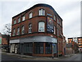
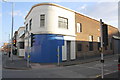
Art deco under demolition
Looks like a motor workshop originally.
Image: © David Lally
Taken: 6 Aug 2022
0.05 miles
9
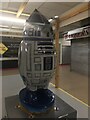
'R2 Tweet2', Hoodwinked 2018, Victoria Centre Market
'Hoodwinked: a twist on the tale' was a city-wide art project that ran from July 7th to September 30th, with 33 large plastic robins placed around the city on a walking trail. Each bird was decorated with a particular theme relating to where they were placed and the businesses sponsoring them. The theme of robins was chosen due to the city's famous connection with the legendary outlaw, Robin Hood.
This bird was titled 'R2 Tweet2', was sponsored by Nottingham Markets and was designed by Mik Richardson. It was designed to look like the droid R2-D2 from the popular Star Wars films.
Image: © Bryn Holmes
Taken: 22 Sep 2018
0.05 miles
10
Junction of Howard Street and Huntingdon Street
There is an OS benchmark Image on the wall to the right of the white door surround
Image: © Roger Templeman
Taken: 30 Mar 2013
0.06 miles