IMAGES TAKEN NEAR TO
Staunton In The Vale, NOTTINGHAM, NG13 9QB
Introduction
This page details the photographs taken nearby to NG13 9QB by members of the Geograph project.
The Geograph project started in 2005 with the aim of publishing, organising and preserving representative images for every square kilometre of Great Britain, Ireland and the Isle of Man.

There are currently over 7.5m images from over14,400 individuals and you can help contribute to the project by visiting https://www.geograph.org.uk
Image Map
Images are licensed for reuse under creativecommons.org/licenses/by-sa/2.0
Notes
- Clicking on the map will re-center to the selected point.
- The higher the marker number, the further away the image location is from the centre of the postcode.
Image Listing (5 Images Found)
Images are licensed for reuse under creativecommons.org/licenses/by-sa/2.0
Image
Details
Distance
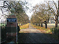
2
Track from Staunton Works joins lane to Staunton In The Vale
Image: © J.Hannan-Briggs
Taken: 18 Sep 2011
0.14 miles
3
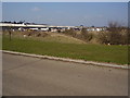
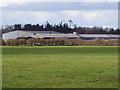
Works from approach road near Staunton
Bullock and Driffield make roof trusses on this site next to the former railway line from Newark to Leicester. There was talk of reopening this route to take freight traffic off the East Coast Main Line. There was lots of such ideas that came to nothing.
Image: © Ken Brockway
Taken: 25 Mar 2007
0.19 miles
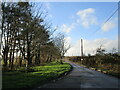
4
Works by the former railway line near Staunton
Image: © Ken Brockway
Taken: 3 Mar 2007
0.21 miles