IMAGES TAKEN NEAR TO
Sutton Lane, NOTTINGHAM, NG13 9PY
Introduction
This page details the photographs taken nearby to Sutton Lane, NG13 9PY by members of the Geograph project.
The Geograph project started in 2005 with the aim of publishing, organising and preserving representative images for every square kilometre of Great Britain, Ireland and the Isle of Man.

There are currently over 7.5m images from over14,400 individuals and you can help contribute to the project by visiting https://www.geograph.org.uk
Image Map
Images are licensed for reuse under creativecommons.org/licenses/by-sa/2.0
Notes
- Clicking on the map will re-center to the selected point.
- The higher the marker number, the further away the image location is from the centre of the postcode.
Image Listing (70 Images Found)
Images are licensed for reuse under creativecommons.org/licenses/by-sa/2.0
Image
Details
Distance
3
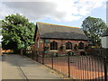
The Village Hall, Granby
The former village school.
Image: © Jonathan Thacker
Taken: 13 Aug 2019
0.15 miles
4
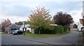
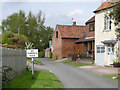
Old Forge Lane, Granby
Off Main Street, at the top of the hill. I suspect that's the former forge behind the bus stop.
Image: © Derek Harper
Taken: 11 Oct 2014
0.16 miles
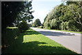
6
Green Lane, Granby
Note the old No Through Road sign still in place.
Image: © Alan Murray-Rust
Taken: 27 Apr 2014
0.17 miles
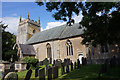
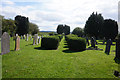
10
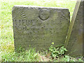
Belvoir Angel, Granby churchyard
Commemorating Katherine Moore, died 1723. Listed Grade II.
Image: © Alan Murray-Rust
Taken: 27 Apr 2014
0.17 miles