IMAGES TAKEN NEAR TO
Longhedge Lane, NOTTINGHAM, NG13 9PL
Introduction
This page details the photographs taken nearby to Longhedge Lane, NG13 9PL by members of the Geograph project.
The Geograph project started in 2005 with the aim of publishing, organising and preserving representative images for every square kilometre of Great Britain, Ireland and the Isle of Man.

There are currently over 7.5m images from over14,400 individuals and you can help contribute to the project by visiting https://www.geograph.org.uk
Image Map
Images are licensed for reuse under creativecommons.org/licenses/by-sa/2.0
Notes
- Clicking on the map will re-center to the selected point.
- The higher the marker number, the further away the image location is from the centre of the postcode.
Image Listing (6 Images Found)
Images are licensed for reuse under creativecommons.org/licenses/by-sa/2.0
Image
Details
Distance
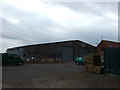
2
Longhedge Lane
Looking towards Lodge Farm.
Image: © Jonathan Thacker
Taken: 14 Mar 2019
0.01 miles
3
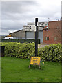
Fingerpost, Lodge Farm, Alverton
The timber post, which appears to have been newly erected, is unusual for the County. The fingers are clearly older and would have come from an earlier concrete post.
Image: © Alan Murray-Rust
Taken: 6 Apr 2014
0.02 miles
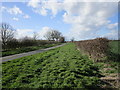
5
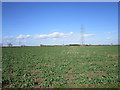
Power line and a field of oilseed rape
North of Longhedge Lane.
Image: © Jonathan Thacker
Taken: 14 Mar 2019
0.19 miles
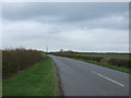
6

Spa Lane
Road from Longhedge Lane to Orston
Image: © Richard Croft
Taken: 28 May 2012
0.22 miles