IMAGES TAKEN NEAR TO
The Walk, NOTTINGHAM, NG13 9NN
Introduction
This page details the photographs taken nearby to The Walk, NG13 9NN by members of the Geograph project.
The Geograph project started in 2005 with the aim of publishing, organising and preserving representative images for every square kilometre of Great Britain, Ireland and the Isle of Man.

There are currently over 7.5m images from over14,400 individuals and you can help contribute to the project by visiting https://www.geograph.org.uk
Image Map (Loading...)


Getting Data...Please wait
Leaflet Map data © OpenStreetMap
Images are licensed for reuse under creativecommons.org/licenses/by-sa/2.0
Notes
- Clicking on the map will re-center to the selected point.
- The higher the marker number, the further away the image location is from the centre of the postcode.
Image Listing (67 Images Found)
Images are licensed for reuse under creativecommons.org/licenses/by-sa/2.0
Image
Details
Distance
1
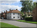
The Ferns, Orston
Dates from about 1785 http://www.britishlistedbuildings.co.uk/en-448149-the-ferns-with-adjoining-railing-shop-co#.VzraJ0fkoeU
Image: © Jonathan Thacker
Taken: 14 May 2016
0.04 miles
3
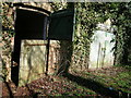
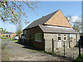
Old Barn off High Street
The stable doors leaning askew and ivy clad walls give access to the old stable, although not for much longer once this old building becomes converted to a residential dwelling.
Image: © Jaime Beckett
Taken: 4 Mar 2006
0.06 miles
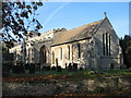
4
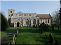
Church of St Mary, Orston
Part of the Cranmer Group of churches. Thomas Cranmer was born at nearby Aslockton.
Image: © Tim Heaton
Taken: 24 Mar 2011
0.06 miles
5
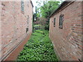
Stream between the houses
Choked with vegetation and pretty well dry. It extends as far as Mill Lane. Is this an entirely artificial channel associated with a mill?
Image: © Jonathan Thacker
Taken: 14 May 2016
0.06 miles
8
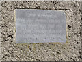
Orston Methodist Church, dedication plaque
This was clearly moved to its present location when the chapel was extended, see http://www.geograph.org.uk/photo/3933957.
Image: © Alan Murray-Rust
Taken: 13 Apr 2014
0.07 miles
9
Orston Methodist Church
The slate plaque to the left of the door of the lean-to tells that the chapel was built in 1869.
Image: © Alan Murray-Rust
Taken: 13 Apr 2014
0.07 miles
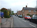
10
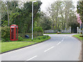
Orston, The Green
Looking west. In the distance are the gates (Listed Grade II) of Orston Hall. The K6 telephone kiosk is no longer in service.
Image: © Alan Murray-Rust
Taken: 13 Apr 2014
0.08 miles