IMAGES TAKEN NEAR TO
Station Road, NOTTINGHAM, NG13 9NB
Introduction
This page details the photographs taken nearby to Station Road, NG13 9NB by members of the Geograph project.
The Geograph project started in 2005 with the aim of publishing, organising and preserving representative images for every square kilometre of Great Britain, Ireland and the Isle of Man.

There are currently over 7.5m images from over14,400 individuals and you can help contribute to the project by visiting https://www.geograph.org.uk
Image Map
Images are licensed for reuse under creativecommons.org/licenses/by-sa/2.0
Notes
- Clicking on the map will re-center to the selected point.
- The higher the marker number, the further away the image location is from the centre of the postcode.
Image Listing (23 Images Found)
Images are licensed for reuse under creativecommons.org/licenses/by-sa/2.0
Image
Details
Distance
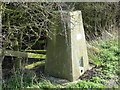
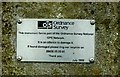
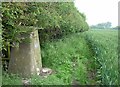
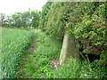
3
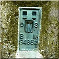
Flush Bracket plate on Orston Triangulation Pillar
Image: © Andrew Tatlow
Taken: 20 Jun 2013
0.08 miles
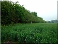
8
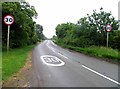
Orston crossroads
Crossroads by Manor Farm at Orston
Image: © Richard Croft
Taken: 28 Aug 2008
0.10 miles
9
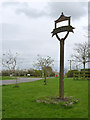
Village sign, Orston
A relatively plain sign without any form of illustration. Sited on the edge of the village at the top of Hill Road.
Image: © Alan Murray-Rust
Taken: 6 Apr 2014
0.11 miles
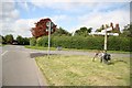
10
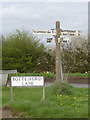
Fingerpost, Bottesford Lane, Orston
Notts C C square concrete post with slotted arms.
Image: © Alan Murray-Rust
Taken: 6 Apr 2014
0.13 miles