IMAGES TAKEN NEAR TO
Main Road, NOTTINGHAM, NG13 9JP
Introduction
This page details the photographs taken nearby to Main Road, NG13 9JP by members of the Geograph project.
The Geograph project started in 2005 with the aim of publishing, organising and preserving representative images for every square kilometre of Great Britain, Ireland and the Isle of Man.

There are currently over 7.5m images from over14,400 individuals and you can help contribute to the project by visiting https://www.geograph.org.uk
Image Map
Images are licensed for reuse under creativecommons.org/licenses/by-sa/2.0
Notes
- Clicking on the map will re-center to the selected point.
- The higher the marker number, the further away the image location is from the centre of the postcode.
Image Listing (44 Images Found)
Images are licensed for reuse under creativecommons.org/licenses/by-sa/2.0
Image
Details
Distance
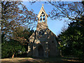
1
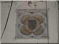
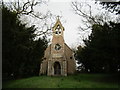
Inscription, St. Mary's church, Barnstone
'This chapel was rebuilt by T D Hall Esq. MDCCCLVI’. The inscription is above the west door.
No longer in use. Planning permission is being sought to convert it to a dwelling. The interior has been stripped of all moveable fittings.
It dates from 1855-7 and replaced an earlier church.
Image: © Jonathan Thacker
Taken: 14 Feb 2020
0.02 miles
2
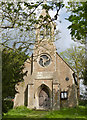
St Mary's Church, Barnstone
A small church, built in 1857 as a chapel of ease to Langar. OS maps show it as St Ethelburga's Church up to the 1950s, but there is nothing I can find to indicate whether this is an error or whether the church was rededicated at some time. There was a church dedicated to St Ethelburga at Langar before the current church there was built (on a different site).
There is a bench mark http://www.geograph.org.uk/photo/3956082 on the north west corner.
Image: © Alan Murray-Rust
Taken: 27 Apr 2014
0.02 miles
3
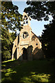
St.Mary's church
Victorian chapel of ease at Barnstone
Image: © Richard Croft
Taken: 3 Sep 2012
0.02 miles
4
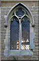
St Mary's Church, Barnstone
Window on the north wall. The church is very small and you can see right through to the south side. The main body of the glass in these windows is clear but the roundels at the top of each one are made of stained glass. You can see the colour in the far window.
Image: © Kate Jewell
Taken: 12 Nov 2007
0.02 miles
5
St Mary's Church, Barnstone
On the edge of the village this small church was built in 1855.
Image: © Kate Jewell
Taken: 12 Nov 2007
0.02 miles
6
Church Farm, Barnstone
The derelict former farmhouse.
Image: © Jonathan Thacker
Taken: 14 Feb 2020
0.02 miles
7
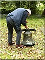
Dismantling a bell, Barnstone
The two bells from the redundant chapel http://www.geograph.org.uk/photo/3956078 were being removed for storage by the diocesan authorities. The inscription shows that it was recast by Taylors of Loughborough in 1956, but also carries the date 1629 transferred from the original at the time of recasting.
Image: © Alan Murray-Rust
Taken: 14 Oct 2020
0.03 miles
8
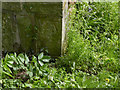
Bench mark, St Mary's Church, Barnstone
See http://www.geograph.org.uk/photo/3956078 for location.
Image: © Alan Murray-Rust
Taken: 27 Apr 2014
0.03 miles
9
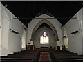
St. Mary's church, Barnstone, interior looking east
No longer in use. Planning permission is being sought to convert it to a dwelling. The interior has been stripped of all moveable fittings.
It dates from 1855-7 and replaced an earlier church.
Image: © Jonathan Thacker
Taken: 14 Feb 2020
0.03 miles
10
St. Mary's church, Barnstone
No longer in use. Planning permission is being sought to convert it to a dwelling.
It dates from 1855-7 and replaced an earlier church.
Image: © Jonathan Thacker
Taken: 14 Feb 2020
0.03 miles