IMAGES TAKEN NEAR TO
Park Road, NOTTINGHAM, NG13 9JG
Introduction
This page details the photographs taken nearby to Park Road, NG13 9JG by members of the Geograph project.
The Geograph project started in 2005 with the aim of publishing, organising and preserving representative images for every square kilometre of Great Britain, Ireland and the Isle of Man.

There are currently over 7.5m images from over14,400 individuals and you can help contribute to the project by visiting https://www.geograph.org.uk
Image Map
Images are licensed for reuse under creativecommons.org/licenses/by-sa/2.0
Notes
- Clicking on the map will re-center to the selected point.
- The higher the marker number, the further away the image location is from the centre of the postcode.
Image Listing (30 Images Found)
Images are licensed for reuse under creativecommons.org/licenses/by-sa/2.0
Image
Details
Distance
1
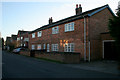
Brick cottages on Works Lane, Barnstone
There are several small blocks of old workers' cottages on Works Lane, built for employees of the cement works which started up in 1885. These are numbers 2 and 4. Where there was once fields in between there are now modern houses, a classic case of in-fill development.
Image: © Kate Jewell
Taken: 12 Nov 2007
0.04 miles
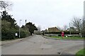
2
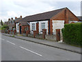
Barnstone Village Hall
This seems to be built in an unusual combination of brick with concrete infilling.
Image: © Alan Murray-Rust
Taken: 27 Apr 2014
0.05 miles
3
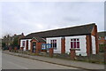
Langar cum Barnstone Village Hall, Barnstone
Though the notice board only proclaims it as the Barnstone Village Hall. There are plans for the building of a new hall https://langarbarnstone.co.uk/
Image: © Tim Heaton
Taken: 22 Mar 2021
0.05 miles
4
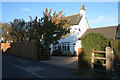
The Old Post Office
On Works Lane, a bright white cottage surrounded by several new brick houses.
Image: © Kate Jewell
Taken: 12 Nov 2007
0.07 miles
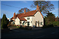
5
The Walnuts, Barnstone
Early Victorian farmhouse at the west end of the village.
Image: © Alan Murray-Rust
Taken: 27 Apr 2014
0.08 miles
6

The Brownie Bench, Barnstone
In memory of Snowy Owl and Mr Brown Owl.
On the small triangular green at the junction of Works Lane.
Image: © Alan Murray-Rust
Taken: 14 Oct 2020
0.08 miles
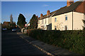
7
Main Road, Barnstone
"Bernestune 1086 (db). ‘Farmstead of a man called Beorn’" https://www.oxfordreference.com/view/10.1093/acref/9780199609086.001.0001/acref-9780199609086. Works Lane, to the right, leads to the long-established cement works.
Image: © Tim Heaton
Taken: 22 Mar 2021
0.09 miles
8
Barnstone Old House
Opposite the junction of Works Lane with Main Road.
Image: © Kate Jewell
Taken: 12 Nov 2007
0.09 miles
9
Workers' cottages on Works Lane, Barnstone
These small semidetached cottages are the last houses before the cement works at the end of Works Lane.
Image: © Kate Jewell
Taken: 12 Nov 2007
0.10 miles
10
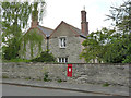
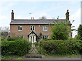
The Manor House, Barnstone
Built in the local blue lias limestone. Originally 17th century, but altered and extended in the 18th and 19th centuries. Listed Grade II. The postbox http://www.geograph.org.uk/photo/3956091 is a relatively uncommon Edward VII wallbox with the later ornate cipher.
Image: © Alan Murray-Rust
Taken: 27 Apr 2014
0.11 miles