IMAGES TAKEN NEAR TO
Butlers Field, NOTTINGHAM, NG13 9HS
Introduction
This page details the photographs taken nearby to Butlers Field, NG13 9HS by members of the Geograph project.
The Geograph project started in 2005 with the aim of publishing, organising and preserving representative images for every square kilometre of Great Britain, Ireland and the Isle of Man.

There are currently over 7.5m images from over14,400 individuals and you can help contribute to the project by visiting https://www.geograph.org.uk
Image Map
Images are licensed for reuse under creativecommons.org/licenses/by-sa/2.0
Notes
- Clicking on the map will re-center to the selected point.
- The higher the marker number, the further away the image location is from the centre of the postcode.
Image Listing (109 Images Found)
Images are licensed for reuse under creativecommons.org/licenses/by-sa/2.0
Image
Details
Distance
1
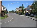
Butlers Field
One leg of a Cul-de-sac collectively known as Butlers Field.
Image: © Tony Bacon
Taken: 10 Sep 2009
0.02 miles
2
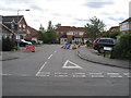
Butlers Field
Road works on Butlers Field at the junction of Barnstone Road.
Image: © Tony Bacon
Taken: 8 Sep 2009
0.04 miles
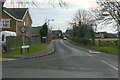
3
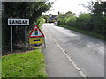
Welcome to Langar
Barnstone Road leading to the village of Langar.
Image: © Tony Bacon
Taken: 8 Sep 2009
0.04 miles
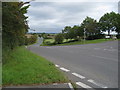
5
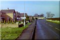
Barnstone Lane, Langar
Looking towards the village from the Bingham Road junction.
Image: © Alan Murray-Rust
Taken: 24 Jan 2011
0.05 miles
6
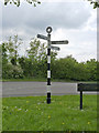
Fingerpost, Bingham Road, Langar
Modern Notts CC fingerpost in traditional style. It has replaced an earlier concrete post http://www.geograph.org.uk/photo/2255598 .
Image: © Alan Murray-Rust
Taken: 27 Apr 2014
0.07 miles
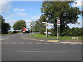
7
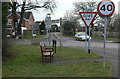
A plethora of signs
The junction of Bingham Road and Barnstone Lane at the edge of Langar village. There are 21 in total, comprising
5 hydrant/valve signs (one is lying down)
4 Road names
3 Speed restrictions
3 Give Way
2 Goods vehicle restrictions (double sided)
1 fingerpost
1 School warning
1 Neighbourhood Watch (part hidden)
1 other name sign (on the fence to the right of the picture)
Note also the local practice of inserting a second pole for some signs to prevent them being rotated.
Image: © Alan Murray-Rust
Taken: 24 Jan 2011
0.08 miles
8
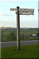
Fingerpost at Langar
Typical Nottinghamshire concrete post with wooden fingers. The big arm has an interesting selection of places indicated - the Blue Circle name disappeared some years ago - and despite having been wedged still droops well off horizontal because of the unbalanced short arm on the other end.
Image: © Alan Murray-Rust
Taken: 24 Jan 2011
0.08 miles
9
Road Signs
Myriad of signs at the junction of Musters Road and Bingham Road at Langar.
Image: © Tony Bacon
Taken: 8 Sep 2009
0.10 miles
10
Bingham Road
The long and winding Bingham Road at the junction of Barnstone Road and Musters Road.
Image: © Tony Bacon
Taken: 8 Sep 2009
0.12 miles