IMAGES TAKEN NEAR TO
Willow Lane, NOTTINGHAM, NG13 9HL
Introduction
This page details the photographs taken nearby to Willow Lane, NG13 9HL by members of the Geograph project.
The Geograph project started in 2005 with the aim of publishing, organising and preserving representative images for every square kilometre of Great Britain, Ireland and the Isle of Man.

There are currently over 7.5m images from over14,400 individuals and you can help contribute to the project by visiting https://www.geograph.org.uk
Image Map
Images are licensed for reuse under creativecommons.org/licenses/by-sa/2.0
Notes
- Clicking on the map will re-center to the selected point.
- The higher the marker number, the further away the image location is from the centre of the postcode.
Image Listing (55 Images Found)
Images are licensed for reuse under creativecommons.org/licenses/by-sa/2.0
Image
Details
Distance
2
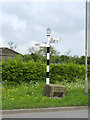
Fingerpost, Harby Road. Cropwell Road, Langar
Modern Notts CC fingerpost (steel with cast aluminium fingers and finial) in traditional style.
Image: © Alan Murray-Rust
Taken: 27 Apr 2014
0.05 miles
5
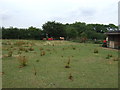
Deep water? Not at the moment
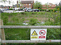
Langar village pond was created in 2012 in part of the car park of the Unicorn's Head pub, on the site of the traditional village pond. Unlike many other parts of Britain, the East Midlands had well below average rainfall during the second half of 2013 and early 2014, with the result that the pond was virtually empty on the occasion of my visit. The Deep water warning and No swimming notice were rather superfluous. The Langar Village Pond Trust has been working to alleviate the problem, including using the roofs of the Unicorn's Head pub to increase rainwater catchment. (Thank you to the Trust's chairman for this information.)
Image: © Alan Murray-Rust
Taken: 27 Apr 2014
0.08 miles
7
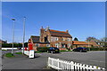
The Unicorn's Head, Langar
Listed Grade II, dated 1717, with a later, tall-chimneyed brew-house to the left https://historicengland.org.uk/listing/the-list/list-entry/1235976. The building underwent major restoration, using historically authentic materials and methods, after a fire in 2015 https://www.greatfoodclub.co.uk/unicorn-rides-again/
Image: © Tim Heaton
Taken: 22 Mar 2021
0.08 miles
8
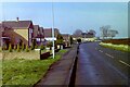
The Unicorn's Head, Langar
A large pub in a village of mainly small cottages and a few large houses. It faces the village green.
Image: © Kate Jewell
Taken: 17 Sep 2005
0.08 miles
9
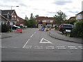
Butlers Field
Road works on Butlers Field at the junction of Barnstone Road.
Image: © Tony Bacon
Taken: 8 Sep 2009
0.08 miles
10
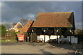
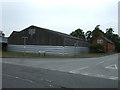
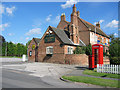
Shed at the back of the Unicorn's Head
This was possibly originally built to shelter carriages of guests, but now makes a fine shelter for outdoor tables.
Image: © Alan Murray-Rust
Taken: 24 Jan 2011
0.09 miles