IMAGES TAKEN NEAR TO
Earl Howe Crescent, NOTTINGHAM, NG13 9HF
Introduction
This page details the photographs taken nearby to Earl Howe Crescent, NG13 9HF by members of the Geograph project.
The Geograph project started in 2005 with the aim of publishing, organising and preserving representative images for every square kilometre of Great Britain, Ireland and the Isle of Man.

There are currently over 7.5m images from over14,400 individuals and you can help contribute to the project by visiting https://www.geograph.org.uk
Image Map
Images are licensed for reuse under creativecommons.org/licenses/by-sa/2.0
Notes
- Clicking on the map will re-center to the selected point.
- The higher the marker number, the further away the image location is from the centre of the postcode.
Image Listing (124 Images Found)
Images are licensed for reuse under creativecommons.org/licenses/by-sa/2.0
Image
Details
Distance
1
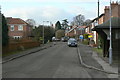
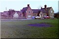
Main Street, Langar
Leading up from Cropwell Road to Langar House and the Church.
Image: © Alan Murray-Rust
Taken: 24 Jan 2011
0.04 miles
2
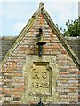
School bell and datestone on the Old Schoolhouse, Langar
Image: © Rob Howl
Taken: 9 Sep 2012
0.04 miles
3
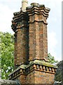
Superb chimneys on the Old Schoolhouse
The twin triple chimneys tell us that this school was not built on a budget...
Image: © Rob Howl
Taken: 9 Sep 2012
0.05 miles
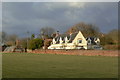
4
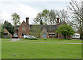
The old school, Langar
Built 1842 as a church school, now converted to residential use. Listed Grade II.
Image: © Alan Murray-Rust
Taken: 27 Apr 2014
0.05 miles
5
The Old School, Langar, 1981
Built in 1842. Now converted to houses.
Image: © Nigel Thompson
Taken: 12 Mar 1981
0.05 miles
6
Church Farm, Langar
The farm is now simply residential property. The wall between it and the field is of some age, dating from the 18th century and being Listed Grade II. It was originally the boundary of formal gardens which filled the paddock in the foreground.
Image: © Alan Murray-Rust
Taken: 24 Jan 2011
0.06 miles
7

Main Street, Langar , Nottinghamshire
The end wall of the large pub on the village green can just be seen behind the red brick cottages.
Image: © Kate Jewell
Taken: 17 Sep 2005
0.06 miles
8
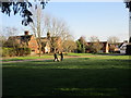
Walking the dog at Langar
The building on the left is the schoolhouse dating from 1842 https://historicengland.org.uk/listing/the-list/list-entry/1235969
Image: © Jonathan Thacker
Taken: 6 Mar 2020
0.07 miles
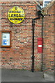
9
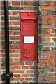
Victorian wall box, Langar
This is now out of service, having been replaced by a modern pillar box http://www.geograph.org.uk/photo/2255659 , but retains its information sheet and is in generally good order. It was probably replaced due to having a narrow posting slot.
Image: © Alan Murray-Rust
Taken: 24 Jan 2011
0.07 miles
10
Two fine survivals
Attached to the end wall of the Unicorn's Head public house are an early style AA village sign, and a nice VR wall box. Earlier views show that the AA sign used to be position on the right hand gable wall.
Image: © Alan Murray-Rust
Taken: 24 Jan 2011
0.07 miles