IMAGES TAKEN NEAR TO
Main Street, NOTTINGHAM, NG13 9HE
Introduction
This page details the photographs taken nearby to Main Street, NG13 9HE by members of the Geograph project.
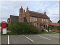
The Geograph project started in 2005 with the aim of publishing, organising and preserving representative images for every square kilometre of Great Britain, Ireland and the Isle of Man.

There are currently over 7.5m images from over14,400 individuals and you can help contribute to the project by visiting https://www.geograph.org.uk
Image Map
Images are licensed for reuse under creativecommons.org/licenses/by-sa/2.0
Notes
- Clicking on the map will re-center to the selected point.
- The higher the marker number, the further away the image location is from the centre of the postcode.
Image Listing (120 Images Found)
Images are licensed for reuse under creativecommons.org/licenses/by-sa/2.0
Image
Details
Distance
1
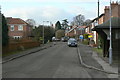
Main Street, Langar
Leading up from Cropwell Road to Langar House and the Church.
Image: © Alan Murray-Rust
Taken: 24 Jan 2011
0.02 miles
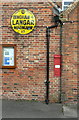
2
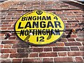
Old circular AA Sign on the Unicorn's Head, Langar
Old AA Sign on the west facing wall of the Unicorn's Head PH on Main Street, Langar, 4 miles south of Bingham. Langar cum Barnstone parish.
This is the circular but not quite conforming to the other two circular styles type. showing distances Bingham 4 Nottingham 12.
There were five series of AA signs, mostly dating from 1923 and made by Francis & Co / Franco in Deptford, London. The village name and distance to London were usually displayed, but not on this sign.
See also https://www.geograph.org.uk/photo/2255677 and https://www.flickr.com/photos/oxfordshirechurches/18028032162.
Milestone Society National ID: NT-LANG
Image: © Milestone Society
Taken: Unknown
0.03 miles
3
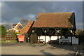
Shed at the back of the Unicorn's Head
This was possibly originally built to shelter carriages of guests, but now makes a fine shelter for outdoor tables.
Image: © Alan Murray-Rust
Taken: 24 Jan 2011
0.03 miles
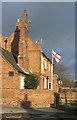
4

Main Street, Langar , Nottinghamshire
The end wall of the large pub on the village green can just be seen behind the red brick cottages.
Image: © Kate Jewell
Taken: 17 Sep 2005
0.04 miles
5
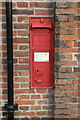
Victorian wall box, Langar
This is now out of service, having been replaced by a modern pillar box http://www.geograph.org.uk/photo/2255659 , but retains its information sheet and is in generally good order. It was probably replaced due to having a narrow posting slot.
Image: © Alan Murray-Rust
Taken: 24 Jan 2011
0.04 miles
6
Two fine survivals
Attached to the end wall of the Unicorn's Head public house are an early style AA village sign, and a nice VR wall box. Earlier views show that the AA sign used to be position on the right hand gable wall.
Image: © Alan Murray-Rust
Taken: 24 Jan 2011
0.04 miles
7
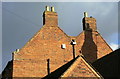
The value of taking all sorts of photographs
I took this shot simply because I liked the shapes of the gables, with their traditional brickwork, rising sunlit against the dark sky. Only after I got home did I notice the date 1717 built into the brickwork. This is the western end of the Unicorn's Head at Langar, which is Listed Grade II
Image: © Alan Murray-Rust
Taken: 24 Jan 2011
0.04 miles
8
The Unicorn's Head, Langar
Glowing brickwork against a dark sky. The extension in the foreground is the former brewhouse, which explains the impressive chimney stack.
Image: © Alan Murray-Rust
Taken: 24 Jan 2011
0.04 miles
9
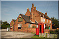
Unicorns Head
Grade II listed village pub with a date of 1717 prominently detailed in the brickwork on the northern gable and the former brewhouse with an impressive chimney stack, now incorporated into the pub.
Image: © Richard Croft
Taken: 3 Sep 2012
0.04 miles
10
The Unicorn's Head
A few photos already on the site, but no close-ups of the sign, so: Image
Building is Grade II listed way back in 1952! List Entry Number: 1235976 https://historicengland.org.uk/listing/the-list/list-entry/1235976?section=official-list-entry
Image: © David Lally
Taken: 4 Oct 2022
0.04 miles