IMAGES TAKEN NEAR TO
Langar Lane, NOTTINGHAM, NG13 9HB
Introduction
This page details the photographs taken nearby to Langar Lane, NG13 9HB by members of the Geograph project.
The Geograph project started in 2005 with the aim of publishing, organising and preserving representative images for every square kilometre of Great Britain, Ireland and the Isle of Man.

There are currently over 7.5m images from over14,400 individuals and you can help contribute to the project by visiting https://www.geograph.org.uk
Image Map
Images are licensed for reuse under creativecommons.org/licenses/by-sa/2.0
Notes
- Clicking on the map will re-center to the selected point.
- The higher the marker number, the further away the image location is from the centre of the postcode.
Image Listing (12 Images Found)
Images are licensed for reuse under creativecommons.org/licenses/by-sa/2.0
Image
Details
Distance
1
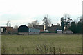
Priory Place
This is the house just to the right of centre. It may be close to the location of the old Saxon priory, which was replaced by the current parish church. It was built as the main residence for Langar Hall Farm.
Image: © Alan Murray-Rust
Taken: 24 Jan 2011
0.04 miles
2
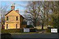
Langar Hall Lodge
On Cropwell Road. The Hall is now a Hotel and upmarket restaurant.
Image: © Alan Murray-Rust
Taken: 24 Jan 2011
0.18 miles
3
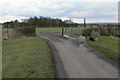
Cattle grid and gate on Langar Lane east of Newlands driveway
Image: © Andrew Tatlow
Taken: 11 Sep 2017
0.21 miles
4
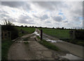
Cattle grid near Langar
It's clear that the cattle grid is not normally needed; the direct line of the road passes through the gate, which is clearly normally open.
Image: © Alan Murray-Rust
Taken: 24 Jan 2011
0.21 miles
5
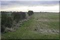
Enclosure ditch
The ditch and hedge have clearly been cut through the ridge and furrow cultivation pattern, as can be seen by the way spoil has been heaped between the ridges. To the left of the hedge the area has clearly been under arable farming as the ridge pattern has completely disappeared, while to the right the land is clearly principally used for stock grazing, and the ridge and furrow pattern remains. Enclosures here took place as early as the end of the 17th century.
Image: © Alan Murray-Rust
Taken: 24 Jan 2011
0.22 miles
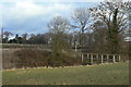
6
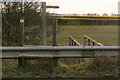
Stile and footbridge
This unusual stile has been created to allow pedestrians to climb safely over the crash barrier at the roadside.
Image: © Alan Murray-Rust
Taken: 24 Jan 2011
0.22 miles
7
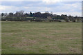
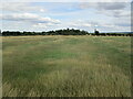
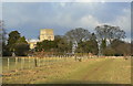
Landscape at Langar
In the foreground can be seen the ridge and furrow pattern of the old medieval field system. The village of Langar stands on the higher ground behind with the church and Langar Hall hidden by the trees just left of centre.
Image: © Alan Murray-Rust
Taken: 24 Jan 2011
0.22 miles
8
Footbridge near Langar
This carries a footpath between Langar and Colston Bassett over the Stroom Dyke.
Image: © Alan Murray-Rust
Taken: 24 Jan 2011
0.23 miles
9
Footpath to Langar Church
Running roughly parallel to the drive to Langar Hall, it has recently been planted with trees to form an avenue.
Image: © Alan Murray-Rust
Taken: 24 Jan 2011
0.23 miles