IMAGES TAKEN NEAR TO
Granby Lane, NOTTINGHAM, NG13 9FZ
Introduction
This page details the photographs taken nearby to Granby Lane, NG13 9FZ by members of the Geograph project.
The Geograph project started in 2005 with the aim of publishing, organising and preserving representative images for every square kilometre of Great Britain, Ireland and the Isle of Man.

There are currently over 7.5m images from over14,400 individuals and you can help contribute to the project by visiting https://www.geograph.org.uk
Image Map
Images are licensed for reuse under creativecommons.org/licenses/by-sa/2.0
Notes
- Clicking on the map will re-center to the selected point.
- The higher the marker number, the further away the image location is from the centre of the postcode.
Image Listing (2 Images Found)
Images are licensed for reuse under creativecommons.org/licenses/by-sa/2.0
Image
Details
Distance
1
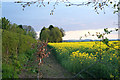
Rape field near Whatton, Nottinghamshire
This field of oil seed rape is alongside the farm road to Vicar's Croft (this square) and Whatton Fields (Image). The hills in the distance are bounding the SW side of the Vale of Belvoir.
Image: © Kate Jewell
Taken: 1 May 2006
0.20 miles
2
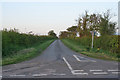
Conery Lane near Whatton
Looking towards the A52 from the junction with Granby Lane.
Image: © Kate Jewell
Taken: 1 May 2006
0.20 miles