IMAGES TAKEN NEAR TO
Conery Lane, NOTTINGHAM, NG13 9FJ
Introduction
This page details the photographs taken nearby to Conery Lane, NG13 9FJ by members of the Geograph project.
The Geograph project started in 2005 with the aim of publishing, organising and preserving representative images for every square kilometre of Great Britain, Ireland and the Isle of Man.

There are currently over 7.5m images from over14,400 individuals and you can help contribute to the project by visiting https://www.geograph.org.uk
Image Map
Images are licensed for reuse under creativecommons.org/licenses/by-sa/2.0
Notes
- Clicking on the map will re-center to the selected point.
- The higher the marker number, the further away the image location is from the centre of the postcode.
Image Listing (7 Images Found)
Images are licensed for reuse under creativecommons.org/licenses/by-sa/2.0
Image
Details
Distance
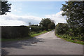
5
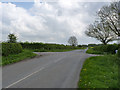
Granby Lane at Conery Lane
Not a full crossroads as the track to the right is farm access.
Image: © Alan Murray-Rust
Taken: 27 Apr 2014
0.16 miles
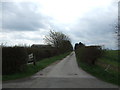
6
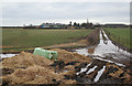
Whatton Fields
The right of way theoretically passes through the morass in the foreground!
Image: © Alan Murray-Rust
Taken: 28 Jan 2007
0.17 miles
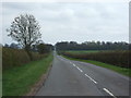
7
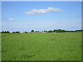
Grassfield near Whatton Fields Farm
Image: © Jonathan Thacker
Taken: 29 May 2016
0.23 miles