IMAGES TAKEN NEAR TO
Manor Lane, NOTTINGHAM, NG13 9EX
Introduction
This page details the photographs taken nearby to Manor Lane, NG13 9EX by members of the Geograph project.
The Geograph project started in 2005 with the aim of publishing, organising and preserving representative images for every square kilometre of Great Britain, Ireland and the Isle of Man.

There are currently over 7.5m images from over14,400 individuals and you can help contribute to the project by visiting https://www.geograph.org.uk
Image Map
Images are licensed for reuse under creativecommons.org/licenses/by-sa/2.0
Notes
- Clicking on the map will re-center to the selected point.
- The higher the marker number, the further away the image location is from the centre of the postcode.
Image Listing (2 Images Found)
Images are licensed for reuse under creativecommons.org/licenses/by-sa/2.0
Image
Details
Distance
1
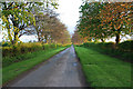
Manor Lane near Whatton, Nottinghamshire
Last of the evening sunshine catches this fine avenue of beech along this narrow country lane which is also known as Hall Lane. Looking towards Whatton Manor.
Image: © Kate Jewell
Taken: 1 May 2006
0.22 miles
2
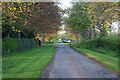
Manor Lane near Whatton, Nottinghamshire
Looking towards the A52. The lane, also known as Hall Lane, used to join the main road here but now you have to turn left to the re-designed junction.
Image: © Kate Jewell
Taken: 1 May 2006
0.22 miles