IMAGES TAKEN NEAR TO
Scarrington Road, NOTTINGHAM, NG13 9DH
Introduction
This page details the photographs taken nearby to Scarrington Road, NG13 9DH by members of the Geograph project.
The Geograph project started in 2005 with the aim of publishing, organising and preserving representative images for every square kilometre of Great Britain, Ireland and the Isle of Man.

There are currently over 7.5m images from over14,400 individuals and you can help contribute to the project by visiting https://www.geograph.org.uk
Image Map
Images are licensed for reuse under creativecommons.org/licenses/by-sa/2.0
Notes
- Clicking on the map will re-center to the selected point.
- The higher the marker number, the further away the image location is from the centre of the postcode.
Image Listing (7 Images Found)
Images are licensed for reuse under creativecommons.org/licenses/by-sa/2.0
Image
Details
Distance
3
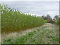
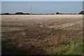
Biofuel plantation
Willow for coppicing near Hawksworth.
Image: © Alan Murray-Rust
Taken: 6 Apr 2014
0.15 miles
4
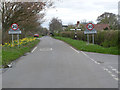
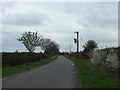
Offset crossroads, Hawksworth
A single fingerpost is placed midway between the two junctions.
Image: © Alan Murray-Rust
Taken: 6 Apr 2014
0.18 miles
5
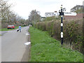
Fingerpost, Hawksworth crossroads
Notts C C traditional cast-iron with plain finial.
Image: © Alan Murray-Rust
Taken: 6 Apr 2014
0.18 miles