IMAGES TAKEN NEAR TO
Cliff Hill Lane, NOTTINGHAM, NG13 9AP
Introduction
This page details the photographs taken nearby to Cliff Hill Lane, NG13 9AP by members of the Geograph project.
The Geograph project started in 2005 with the aim of publishing, organising and preserving representative images for every square kilometre of Great Britain, Ireland and the Isle of Man.

There are currently over 7.5m images from over14,400 individuals and you can help contribute to the project by visiting https://www.geograph.org.uk
Image Map
Images are licensed for reuse under creativecommons.org/licenses/by-sa/2.0
Notes
- Clicking on the map will re-center to the selected point.
- The higher the marker number, the further away the image location is from the centre of the postcode.
Image Listing (14 Images Found)
Images are licensed for reuse under creativecommons.org/licenses/by-sa/2.0
Image
Details
Distance
1
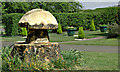
Toadstool Tree Stump
Carved out of remaining stump of felled tree.
Image: © Carolyn Mansfield
Taken: 25 Apr 2007
0.14 miles
2
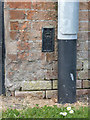
Flush bracket bench mark, Corner Farm, Aslockton
See http://www.geograph.org.uk/photo/3923405 for location.
Image: © Alan Murray-Rust
Taken: 13 Apr 2014
0.21 miles
3
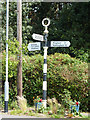
Aslockton fingerpost
Traditional fingerpost at the junction of Cliffhill Lane, Mill Road and Main Street
Image: © Richard Croft
Taken: 15 Jul 2011
0.22 miles
4
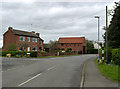
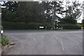
Aslockton, junction of Mill Lane and Cliffhill Lane
The buildings once made up Corner Farm. The fingerpost is a Notts C C traditional cast-iron type with annulus finial.
There is a flush bracket http://www.geograph.org.uk/photo/3931862 on the barn, to the right of the doorway.
Image: © Alan Murray-Rust
Taken: 6 Apr 2014
0.22 miles
5
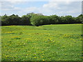
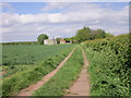
Hills and hollows
Most likely to be the remains of fishponds rather than the motte and bailey marked by OS.
Image: © Jonathan Thacker
Taken: 14 May 2016
0.22 miles
6
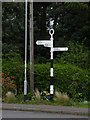
Fingerpost, Mill Lane, Aslockton
Notts C C traditional cast-iron with annulus finial.
Image: © Alan Murray-Rust
Taken: 6 Apr 2014
0.22 miles
8
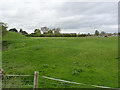
Fishponds at Cranmer's Mound
Possibly the remains of a motte and bailey castle, the mound (left) was certainly used later as a prospect mound overlooking ornamental grounds including fishponds, the latter of which now form the bulk of the surviving earthworks. Scheduled Monument.
Image: © Alan Murray-Rust
Taken: 6 Apr 2014
0.23 miles
10
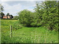
Hollow near Cranmer's Mound
Most likely a fishpond.
Image: © Jonathan Thacker
Taken: 14 May 2016
0.24 miles