IMAGES TAKEN NEAR TO
Newton Lane, NG13 8UW
Introduction
This page details the photographs taken nearby to Newton Lane, NG13 8UW by members of the Geograph project.
The Geograph project started in 2005 with the aim of publishing, organising and preserving representative images for every square kilometre of Great Britain, Ireland and the Isle of Man.

There are currently over 7.5m images from over14,400 individuals and you can help contribute to the project by visiting https://www.geograph.org.uk
Image Map
Images are licensed for reuse under creativecommons.org/licenses/by-sa/2.0
Notes
- Clicking on the map will re-center to the selected point.
- The higher the marker number, the further away the image location is from the centre of the postcode.
Image Listing (12 Images Found)
Images are licensed for reuse under creativecommons.org/licenses/by-sa/2.0
Image
Details
Distance
1
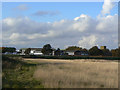
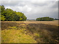
Former RAF Newton
This may well have been recreation space for the personnel, but is now becoming overgrown. The operations buildings beyond are partly reused but many are empty.
Image: © Alan Murray-Rust
Taken: 23 Oct 2009
0.07 miles
2
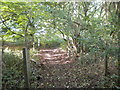
Public footpath in Ash Holt, east of Newton
Image: © Richard Vince
Taken: 15 Oct 2016
0.15 miles
3
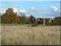
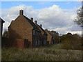
Former RAF Newton
This was probably recreation space for the personnel, but is now becoming overgrown. Beyond can be seen some of the derelict houses. Judging by the size, these would have been allocated to senior officers. empty.
Image: © Alan Murray-Rust
Taken: 23 Oct 2009
0.20 miles
4
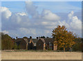
Former RAF Newton
Some of the derelict houses. Judging by the size, these would have been allocated to senior officers. empty.
Image: © Alan Murray-Rust
Taken: 23 Oct 2009
0.21 miles
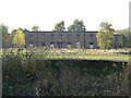
6
Dereliction at RAF Newton
The area of housing nearest to the Fosse Way is becoming increasingly derelict.
Image: © Alan Murray-Rust
Taken: 23 Oct 2009
0.22 miles
7
Former RAF Newton
One of the many derelict buildings on the site.
Image: © Alan Murray-Rust
Taken: 23 Oct 2009
0.22 miles
8
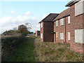
Dereliction at RAF Newton
The area of housing nearest to the Fosse Way is becoming increasingly derelict. Since the base was closed, a bridleway has been established across the airfield site, although this section clearly sees little use.
Image: © Alan Murray-Rust
Taken: 23 Oct 2009
0.22 miles
9
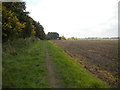
Public footpath east of Newton (2)
Along the edge of a field at the eastern edge of the village.
Image: © Richard Vince
Taken: 15 Oct 2016
0.23 miles
10
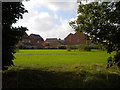
New housing in Newton
Seen from a public footpath that passes along the eastern edge of the village.
Image: © Richard Vince
Taken: 15 Oct 2016
0.24 miles