IMAGES TAKEN NEAR TO
Harebell Gardens, NOTTINGHAM, NG13 8TA
Introduction
This page details the photographs taken nearby to Harebell Gardens, NG13 8TA by members of the Geograph project.
The Geograph project started in 2005 with the aim of publishing, organising and preserving representative images for every square kilometre of Great Britain, Ireland and the Isle of Man.

There are currently over 7.5m images from over14,400 individuals and you can help contribute to the project by visiting https://www.geograph.org.uk
Image Map
Images are licensed for reuse under creativecommons.org/licenses/by-sa/2.0
Notes
- Clicking on the map will re-center to the selected point.
- The higher the marker number, the further away the image location is from the centre of the postcode.
Image Listing (16 Images Found)
Images are licensed for reuse under creativecommons.org/licenses/by-sa/2.0
Image
Details
Distance
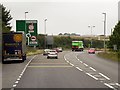
3
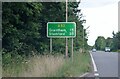
Route confirmation sign on the A52 Bingham Bypass
Image: © David Howard
Taken: 16 Jul 2023
0.08 miles
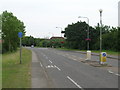
6
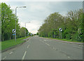
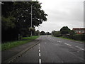
Nottingham Road
Main thoroughfare heading west out of Bingham. Ahead is the A46 roundabout and the filling station on the opposite side.
Image: © Trevor Rickard
Taken: 1 May 2010
0.11 miles
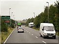
8
No entry to the DFT weigh bridge
From Nottingham Road Bingham.
Image: © Steve Fareham
Taken: 26 Jan 2010
0.11 miles
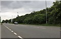
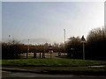
10
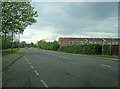
Nottingham Road
Main road heading west out of Bingham. A maze of modern housing estates on both sides.
Image: © Trevor Rickard
Taken: 1 May 2010
0.15 miles