IMAGES TAKEN NEAR TO
Langdale Grove, NOTTINGHAM, NG13 8SS
Introduction
This page details the photographs taken nearby to Langdale Grove, NG13 8SS by members of the Geograph project.
The Geograph project started in 2005 with the aim of publishing, organising and preserving representative images for every square kilometre of Great Britain, Ireland and the Isle of Man.

There are currently over 7.5m images from over14,400 individuals and you can help contribute to the project by visiting https://www.geograph.org.uk
Image Map
Images are licensed for reuse under creativecommons.org/licenses/by-sa/2.0
Notes
- Clicking on the map will re-center to the selected point.
- The higher the marker number, the further away the image location is from the centre of the postcode.
Image Listing (29 Images Found)
Images are licensed for reuse under creativecommons.org/licenses/by-sa/2.0
Image
Details
Distance
1
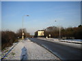
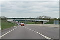
B692 Fosse Road north of old Saxondale Island
Until a new dual carriageway was constructed to the west a few years ago, this former Roman road was the A46.
Image: © Richard Vince
Taken: 29 Dec 2014
0.07 miles
2
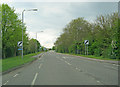
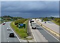
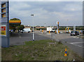
Nottingham Road
Main thoroughfare heading west out of Bingham. Ahead is the A46 roundabout and the filling station on the opposite side.
Image: © Trevor Rickard
Taken: 1 May 2010
0.09 miles
3
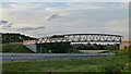
Looking toward a footbridge over the A46
The path from which this was taken goes across this bridge for walkers and cyclists uses this bridge to avoid the danger of the nearby roundabouts which form the junction with the A52.
It forms part of the National Cycling Network route 15.
Image: © David Lally
Taken: 6 Aug 2016
0.09 miles
4
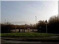
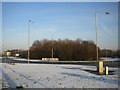
No entry to the DFT weigh bridge
From Nottingham Road Bingham.
Image: © Steve Fareham
Taken: 26 Jan 2010
0.10 miles
6
Old Saxondale Island west of Bingham
This was the junction of the A46 and A52, before the former was replaced with a new A46 a little way behind the photographer.
Image: © Richard Vince
Taken: 29 Dec 2014
0.12 miles
7
Heading for the dark
The A46 at Saxondale interchange (for the A52).
Image: © Alan Murray-Rust
Taken: 14 Oct 2020
0.13 miles
8
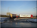
Lorries parked on old A52, Saxondale
These lorries are parked on the old A52 western approach to Saxondale Island, which was severed when the new A46 was built across the alignment (left). This is now merely an access road to a petrol station (behind the photographer).
Image: © Richard Vince
Taken: 29 Dec 2014
0.15 miles
9
Saxondale Filling Station
Located conveniently on the roundabout where the A46 and A52 cross, its future will be less rosy once the new A46 alignment which bypasses the roundabout comes into use.
Image: © Alan Murray-Rust
Taken: 2 Sep 2011
0.15 miles
10
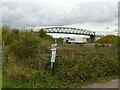
Bridleway bridge over the A46
Just north of Saxondale interchange.
Image: © Alan Murray-Rust
Taken: 14 Oct 2020
0.15 miles