IMAGES TAKEN NEAR TO
Welbeck Grove, NOTTINGHAM, NG13 8RF
Introduction
This page details the photographs taken nearby to Welbeck Grove, NG13 8RF by members of the Geograph project.
The Geograph project started in 2005 with the aim of publishing, organising and preserving representative images for every square kilometre of Great Britain, Ireland and the Isle of Man.

There are currently over 7.5m images from over14,400 individuals and you can help contribute to the project by visiting https://www.geograph.org.uk
Image Map
Images are licensed for reuse under creativecommons.org/licenses/by-sa/2.0
Notes
- Clicking on the map will re-center to the selected point.
- The higher the marker number, the further away the image location is from the centre of the postcode.
Image Listing (16 Images Found)
Images are licensed for reuse under creativecommons.org/licenses/by-sa/2.0
Image
Details
Distance
1
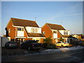
Houses on Forest Road, Bingham
A pair of detached houses with unusual asymmetrical roofs.
Image: © Richard Vince
Taken: 29 Dec 2014
0.05 miles
2
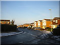
East side of Forest Road, Bingham
Forest Road describes a sideways U shape; this is the central part, with a right angle bend to the west at either end.
Image: © Richard Vince
Taken: 29 Dec 2014
0.07 miles
3
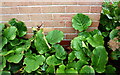
Benchmark on #73 Forest Road
Ordnance Survey cut mark benchmark described on the Bench Mark Database at https://www.bench-marks.org.uk/bm99481
Image: © Roger Templeman
Taken: 10 Sep 2018
0.08 miles
4
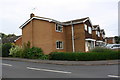
#73 Forest Road at Shelford Drive junction
There is an OS benchmark Image on the near corner, left hand face, of the house
Image: © Roger Templeman
Taken: 10 Sep 2018
0.08 miles
5
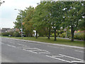
Nottingham Road, Bingham
It's difficult to visualise that a railway bridge once stood at this point; the photograph looks roughly along the alignment of the railway.
Image: © Alan Murray-Rust
Taken: 2 Sep 2011
0.09 miles
6
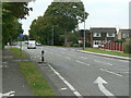
Nottingham Road
Looking west near Meadowsweet Hill.
Image: © Alan Murray-Rust
Taken: 2 Sep 2011
0.10 miles
7
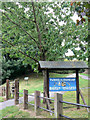
Friendship Tree/Baum der Freundschaft
The tree behind the notice board was planted in October 1984 to commemorate the twinning of Bingham and Wallenfels.
Image: © Alan Murray-Rust
Taken: 2 Sep 2011
0.11 miles
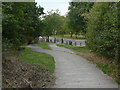
8
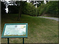
Bingham Linear Park
Created on the alignment of the Barnstone Branch of the Great Northern Railway and London & North Western Railway Joint Line from Market Harborough to Bottesford and Saxondale via Melton Mowbray.
Image: © Alan Murray-Rust
Taken: 2 Sep 2011
0.11 miles
9
Bingham Linear Park
Created on the alignment of the Barnstone Branch of the Great Northern Railway and London & North Western Railway Joint Line from Market Harborough to Bottesford and Saxondale via Melton Mowbray. Looking down onto Nottingham Road from the site of Bingham Road Station. The railway crossed the road by an overbridge.
Image: © Alan Murray-Rust
Taken: 2 Sep 2011
0.13 miles
10
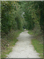
Bingham Linear Park
Created on the alignment of the Barnstone Branch of the Great Northern Railway and London & North Western Railway Joint Line from Market Harborough to Bottesford and Saxondale via Melton Mowbray. The railway ran on embankment at this point, having just crossed the Nottingham Road, and climbing to cut through the side of Toot Hill.
Image: © Alan Murray-Rust
Taken: 2 Sep 2011
0.16 miles