IMAGES TAKEN NEAR TO
Woodpecker Close, NOTTINGHAM, NG13 8QL
Introduction
This page details the photographs taken nearby to Woodpecker Close, NG13 8QL by members of the Geograph project.
The Geograph project started in 2005 with the aim of publishing, organising and preserving representative images for every square kilometre of Great Britain, Ireland and the Isle of Man.

There are currently over 7.5m images from over14,400 individuals and you can help contribute to the project by visiting https://www.geograph.org.uk
Image Map
Images are licensed for reuse under creativecommons.org/licenses/by-sa/2.0
Notes
- Clicking on the map will re-center to the selected point.
- The higher the marker number, the further away the image location is from the centre of the postcode.
Image Listing (18 Images Found)
Images are licensed for reuse under creativecommons.org/licenses/by-sa/2.0
Image
Details
Distance
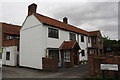
2
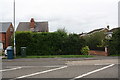
#65 Grantham Road behind a hedge
There is an OS benchmark Image on the brick gatepost on the right hand side of the house entrance drive
Image: © Roger Templeman
Taken: 10 Sep 2018
0.08 miles
3
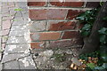
Damaged benchmark on entrance gatepost to #65 Grantham Road
Ordnance Survey cut mark benchmark described on the Bench Mark Database at https://www.bench-marks.org.uk/bm99474
Image: © Roger Templeman
Taken: 10 Sep 2018
0.08 miles
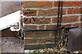
4
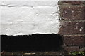
Overpainted benchmark on #1 Grantham Road
Ordnance Survey cut mark benchmark described on the Bench Mark Database at https://www.bench-marks.org.uk/bm99472
Image: © Roger Templeman
Taken: 10 Sep 2018
0.16 miles
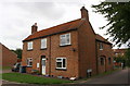
5
#1 Grantham Road
There is an OS benchmark Image on the near corner of the house at its junction with an abutting brick wall
Image: © Roger Templeman
Taken: 10 Sep 2018
0.17 miles
7
#12 East Street
There is an OS benchmark Image at the near corner of the house, left of the street name sign
Image: © Roger Templeman
Taken: 10 Sep 2018
0.22 miles
8
Benchmark on #12 East Street
Ordnance Survey cut mark benchmark described on the Bench Mark Database at https://www.bench-marks.org.uk/bm99468
Image: © Roger Templeman
Taken: 10 Sep 2018
0.22 miles
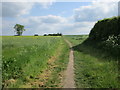
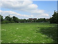
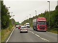
10
Footpath across a field off Cogley Lane, Bingham
Image: © Richard Vince
Taken: 29 Dec 2014
0.23 miles