IMAGES TAKEN NEAR TO
Osprey Close, NOTTINGHAM, NG13 8QG
Introduction
This page details the photographs taken nearby to Osprey Close, NG13 8QG by members of the Geograph project.
The Geograph project started in 2005 with the aim of publishing, organising and preserving representative images for every square kilometre of Great Britain, Ireland and the Isle of Man.

There are currently over 7.5m images from over14,400 individuals and you can help contribute to the project by visiting https://www.geograph.org.uk
Image Map
Images are licensed for reuse under creativecommons.org/licenses/by-sa/2.0
Notes
- Clicking on the map will re-center to the selected point.
- The higher the marker number, the further away the image location is from the centre of the postcode.
Image Listing (13 Images Found)
Images are licensed for reuse under creativecommons.org/licenses/by-sa/2.0
Image
Details
Distance
3
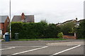
#65 Grantham Road behind a hedge
There is an OS benchmark Image on the brick gatepost on the right hand side of the house entrance drive
Image: © Roger Templeman
Taken: 10 Sep 2018
0.19 miles
4
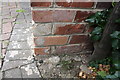
Damaged benchmark on entrance gatepost to #65 Grantham Road
Ordnance Survey cut mark benchmark described on the Bench Mark Database at https://www.bench-marks.org.uk/bm99474
Image: © Roger Templeman
Taken: 10 Sep 2018
0.19 miles
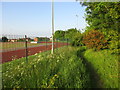

7
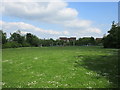
Path through the school
The path is not signposted and it is easy to get lost (as I did).
Image: © Jonathan Thacker
Taken: 29 May 2016
0.22 miles
8
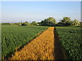
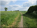
Footpath to Barnstone
Recently sprayed.
Image: © Jonathan Thacker
Taken: 29 May 2016
0.23 miles
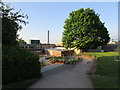
9
Fisher Lane, Bingham
With the aptly named Rose Hip Cottage
Image: © Kate Jewell
Taken: 9 May 2006
0.25 miles
10
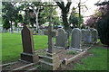
Cemetery on The Banks, Bingham
When this cemetery was first opened in the mid 19th century it was on the outskirts of the village and surrounded by fields. Now it's surrounded by houses.
Image: © Kate Jewell
Taken: 9 May 2006
0.25 miles