IMAGES TAKEN NEAR TO
Croft Rise, NOTTINGHAM, NG13 8PS
Introduction
This page details the photographs taken nearby to Croft Rise, NG13 8PS by members of the Geograph project.
The Geograph project started in 2005 with the aim of publishing, organising and preserving representative images for every square kilometre of Great Britain, Ireland and the Isle of Man.

There are currently over 7.5m images from over14,400 individuals and you can help contribute to the project by visiting https://www.geograph.org.uk
Image Map
Images are licensed for reuse under creativecommons.org/licenses/by-sa/2.0
Notes
- Clicking on the map will re-center to the selected point.
- The higher the marker number, the further away the image location is from the centre of the postcode.
Image Listing (25 Images Found)
Images are licensed for reuse under creativecommons.org/licenses/by-sa/2.0
Image
Details
Distance
1
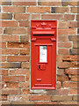
East Bridgford postbox ref NG13 35
Standard VR wall box with widened posting slot built into a farm building. The official designation is simple 'East Bridgford' although there are three other boxes in the village. This could well have been the first one installed.
Image: © Alan Murray-Rust
Taken: 6 Apr 2014
0.07 miles
2
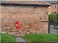
East Bridgford postbox ref NG13 34
Standard VR wall box with widened posting slot built into a farm building. The official designation is simple 'East Bridgford' although there are three other boxes in the village. This could well have been the first one installed.
Image: © Alan Murray-Rust
Taken: 6 Apr 2014
0.07 miles
3
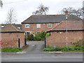
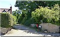
Former farm buildings on Kneeton Road
Old OS maps give no clue as to what the name of the farm might have been.
Image: © Alan Murray-Rust
Taken: 6 Apr 2014
0.08 miles
4
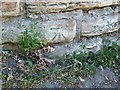
Bench Mark, Kneeton Road, East Bridgford
See http://www.geograph.org.uk/photo/6495135 for location.
Image: © Alan Murray-Rust
Taken: 29 May 2020
0.11 miles
5
Brown's Lane, East Bridgford
One of the many traditional footpaths that criss-cross the village.
There is a benchmark http://www.geograph.org.uk/photo/6495130 to the right of the concrete litter bin.
Image: © Alan Murray-Rust
Taken: 29 May 2020
0.11 miles
6
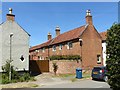
63 Kneeton Road, East Bridgford
Mid 18th century former farmhouse with adjoining range of outbuildings. Listed Grade II.
Image: © Alan Murray-Rust
Taken: 29 May 2020
0.11 miles
7
Manor Lodge, East Bridgford
Dating from c.1820 when the house http://www.geograph.org.uk/photo/6493860 was expanded. Classic Regency style with shallow roof pitch and wide eaves. The right hand bay is a 21st century addition. Listed Grade II.
Image: © Alan Murray-Rust
Taken: 29 May 2020
0.11 miles
8
The Old Hall, East Bridgford
Early 18th century country house with early 20th century wing to the right. Listed Grade II.
Image: © Alan Murray-Rust
Taken: 29 May 2020
0.14 miles
9
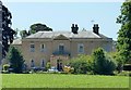
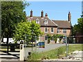
The Manor House, East Bridgford
Mid 18th century house extended c.1820, now a residential nursing home. Listed Grade II.
Image: © Alan Murray-Rust
Taken: 29 May 2020
0.14 miles
10
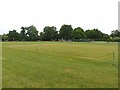
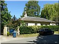
Butt Close, East Bridgford
The area has been a recreation ground since the medieval period, when it was the archery practice field (butts), and is covenanted to restrict its use for recreational purposes. In the foreground the square of the village cricket club – yet to start playing this year due to the Covid-19 lockdown. At the far side is an extensive play area opened in 2011.
Image: © Alan Murray-Rust
Taken: 7 Jun 2020
0.16 miles