IMAGES TAKEN NEAR TO
Fosse Road, NOTTINGHAM, NG13 8JJ
Introduction
This page details the photographs taken nearby to Fosse Road, NG13 8JJ by members of the Geograph project.
The Geograph project started in 2005 with the aim of publishing, organising and preserving representative images for every square kilometre of Great Britain, Ireland and the Isle of Man.

There are currently over 7.5m images from over14,400 individuals and you can help contribute to the project by visiting https://www.geograph.org.uk
Image Map
Images are licensed for reuse under creativecommons.org/licenses/by-sa/2.0
Notes
- Clicking on the map will re-center to the selected point.
- The higher the marker number, the further away the image location is from the centre of the postcode.
Image Listing (33 Images Found)
Images are licensed for reuse under creativecommons.org/licenses/by-sa/2.0
Image
Details
Distance
2
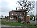
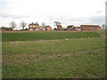
Red Lodge
Originally a farm, more recently an antiques centre, and at the time of this view undergoing further transformation.
Image: © Alan Murray-Rust
Taken: 6 Dec 2009
0.00 miles
4
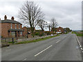
The old main road at Red Lodge (former A46)
Beyond the junction with Lodge Lane, the road is a narrow dead-end track for local access only.
Image: © Alan Murray-Rust
Taken: 6 Apr 2014
0.02 miles
5
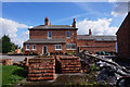
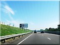
Red Lodge and the new A46
Much of the new A46 has been constructed in cuttings, as here. Red Lodge was once a public house on the Fosse Way but has long since ceased to have that function.
Image: © Jonathan Thacker
Taken: 10 Mar 2012
0.02 miles
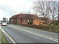
6
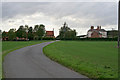
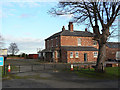
Stony Dale
Lodge Lane meets the A46 here. The farm buildings on the left have been converted to residential use. The building on the right is the old Red Lodge public house, now being converted into a house.
Image: © Kate Jewell
Taken: 21 Oct 2006
0.03 miles
7
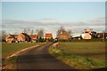
Stony Dale
View from Lodge Lane towards the A46, Red Lodge and The Rafters
Image: © Richard Croft
Taken: 3 Dec 2008
0.04 miles
9
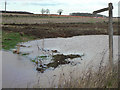
Footpath signpost
Paddling is not allowed, as despite the sign, the footpath is temporarily closed due to the A46 construction.
Image: © Alan Murray-Rust
Taken: 6 Dec 2009
0.05 miles
10
The Rafters
Converted farm buildings at Red Lodge, alongside the Fosse Way.
Image: © Alan Murray-Rust
Taken: 6 Dec 2009
0.06 miles