IMAGES TAKEN NEAR TO
Wiverton, Bingham, NOTTINGHAM, NG13 8GU
Introduction
This page details the photographs taken nearby to NG13 8GU by members of the Geograph project.
The Geograph project started in 2005 with the aim of publishing, organising and preserving representative images for every square kilometre of Great Britain, Ireland and the Isle of Man.

There are currently over 7.5m images from over14,400 individuals and you can help contribute to the project by visiting https://www.geograph.org.uk
Image Map
Images are licensed for reuse under creativecommons.org/licenses/by-sa/2.0
Notes
- Clicking on the map will re-center to the selected point.
- The higher the marker number, the further away the image location is from the centre of the postcode.
Image Listing (9 Images Found)
Images are licensed for reuse under creativecommons.org/licenses/by-sa/2.0
Image
Details
Distance
1
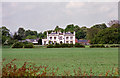
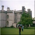
Wiverton Hall, Langer
A castellated house of 1814 in a Tudor-Gothic style. Turrets and chimneys abound. It incorporates at late C15th gatehouse. Grade II* listed.
Image: © Stephen Richards
Taken: 7 May 2003
0.01 miles
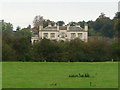
2
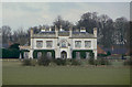
Wiverton Hall
This front represents a fine example of Regency Tudor Revival and dates from 1814. In fact the Hall is based on a 15th century gatehouse which has been incorporated in the later expansion. It exists at the rear of the building. Listed Grade II*
Image: © Alan Murray-Rust
Taken: 24 Jan 2011
0.01 miles
4
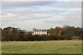
Wiverton Hall
Regency Gothick mansion of 1814 seen from Wiverton Smite Bridge
Image: © Richard Croft
Taken: 12 Nov 2008
0.02 miles
5
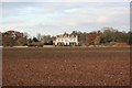
Wiverton Hall
Regency Gothick mansion of 1814 with 15th century origins, seen from Bingham Road
Image: © Richard Croft
Taken: 12 Nov 2008
0.02 miles
6
Wiverton Hall, near Tithby, Nottinghamshire
Wiverton Hall just south of Tithby was held by the kings' men from 1643 to 1645, controlling movement across this part of the Vale. There is a Civil War Battery in the grounds. Mrs Chaworth Musters wrote the book "A Cavalier Stronghold - a romance of the Vale of Belvoir" in 1890. The Chaworth family had owned Wiverton since the reign of Edward III.
Image: © Kate Jewell
Taken: 14 Oct 2005
0.04 miles
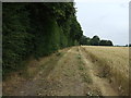
7
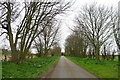
Driveway to Wiverton Hall
The original hall was a base for Royalists in the Civil War, but largely destroyed after the Parliamentary victory https://en.wikipedia.org/wiki/Wiverton_Hall
Image: © Tim Heaton
Taken: 22 Mar 2021
0.17 miles