IMAGES TAKEN NEAR TO
Cropwell Road, NOTTINGHAM, NG13 8GS
Introduction
This page details the photographs taken nearby to Cropwell Road, NG13 8GS by members of the Geograph project.
The Geograph project started in 2005 with the aim of publishing, organising and preserving representative images for every square kilometre of Great Britain, Ireland and the Isle of Man.

There are currently over 7.5m images from over14,400 individuals and you can help contribute to the project by visiting https://www.geograph.org.uk
Image Map
Images are licensed for reuse under creativecommons.org/licenses/by-sa/2.0
Notes
- Clicking on the map will re-center to the selected point.
- The higher the marker number, the further away the image location is from the centre of the postcode.
Image Listing (72 Images Found)
Images are licensed for reuse under creativecommons.org/licenses/by-sa/2.0
Image
Details
Distance
1
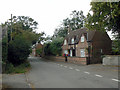
The Old Vicarage, Tithby
Early 18th century with 19th century alterations. The style of building with attic storey with dormers is relatively unusual for the region. Listed Grade II.
Image: © Alan Murray-Rust
Taken: 2 Sep 2011
0.00 miles
2
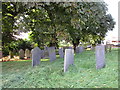
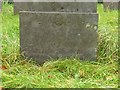
Swithland slate headstones in the churchyard, Tithby
Typical of the Vale of Belvoir and nearby areas. An over view of such headstones can be found at http://www.le.ac.uk/emoha/leicester/swithland.html
Image: © Jonathan Thacker
Taken: 23 Sep 2016
0.01 miles
3
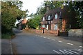
Cropwell Road, Tithby
Brick built cottages just west of the church.
Image: © Kate Jewell
Taken: 15 Sep 2011
0.01 miles
4
Holy Trinity Church, Tithby
There are some fine slate head stones in this church yard.
Image: © Kate Jewell
Taken: 15 Sep 2011
0.01 miles
5
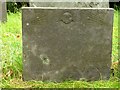
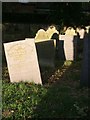
Belvoir Angel headstone, Tithby Churchyard
To Mary, wife of William Spybye, d.1723. Listed Grade II as part of a group of 13 stones in this part of the churchyard. See also http://www.geograph.org.uk/photo/5168159
Image: © Alan Murray-Rust
Taken: 23 Oct 2016
0.02 miles
6
Belvoir Angel headstone, Tithby Churchyard
To William Spybye, d.1723. Listed Grade II as part of a group of 13 stones in this part of the churchyard. See also http://www.geograph.org.uk/photo/5168162
Image: © Alan Murray-Rust
Taken: 23 Oct 2016
0.02 miles
7
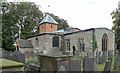
Holy Trinity, Tithby
The church dates back to the 14th Century, with the south aisle being from the 18th century and the brick tower from the late 19th century. The church is Listed Grade I.
A number of the slate gravestones in this part of the churchyard dating from between 1723 and 1815 are also Listed, Grade II, as are the two chest tombs close to the chancel.
Image: © Alan Murray-Rust
Taken: 2 Sep 2011
0.02 miles
8
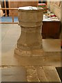
Church of the Holy Trinity, Tithby
The re-worked medieval font showing the date 1662. See also http://www.geograph.org.uk/photo/5168167
Image: © Alan Murray-Rust
Taken: 23 Oct 2016
0.02 miles
9
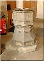
Church of the Holy Trinity, Tithby
The re-worked medieval font showing the initials TS and RD of the churchwardens (CW below). See also http://www.geograph.org.uk/photo/5168170
Image: © Alan Murray-Rust
Taken: 23 Oct 2016
0.02 miles
10
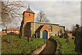
Holy Trinity Church
Grade I listed 14th century church with obvious 18th & 19th century alterations and additions
Image: © Richard Croft
Taken: 6 Feb 2015
0.02 miles