IMAGES TAKEN NEAR TO
Holme Road, NOTTINGHAM, NG13 8DZ
Introduction
This page details the photographs taken nearby to Holme Road, NG13 8DZ by members of the Geograph project.
The Geograph project started in 2005 with the aim of publishing, organising and preserving representative images for every square kilometre of Great Britain, Ireland and the Isle of Man.

There are currently over 7.5m images from over14,400 individuals and you can help contribute to the project by visiting https://www.geograph.org.uk
Image Map
Images are licensed for reuse under creativecommons.org/licenses/by-sa/2.0
Notes
- Clicking on the map will re-center to the selected point.
- The higher the marker number, the further away the image location is from the centre of the postcode.
Image Listing (58 Images Found)
Images are licensed for reuse under creativecommons.org/licenses/by-sa/2.0
Image
Details
Distance
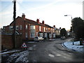
1
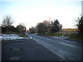
Cogley Lane, Bingham (1)
The cul de sac on the left is also, apparently, considered to be part of Cogley Lane.
Image: © Richard Vince
Taken: 29 Dec 2014
0.08 miles
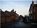
2
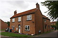
#12 East Street
There is an OS benchmark Image at the near corner of the house, left of the street name sign
Image: © Roger Templeman
Taken: 10 Sep 2018
0.09 miles
3
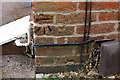
Benchmark on #12 East Street
Ordnance Survey cut mark benchmark described on the Bench Mark Database at https://www.bench-marks.org.uk/bm99468
Image: © Roger Templeman
Taken: 10 Sep 2018
0.09 miles
4
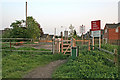
Level Crossing at the end of Cogley Lane
Cogley Lane turns into a rough farm track as it crosses the railway line. The Bingham Centenary Trail footpath crosses as well.
Image: © Kate Jewell
Taken: 9 May 2006
0.10 miles
5
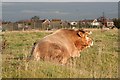
Bigham Bull
A handsome bull at Crow Close in Bingham
Image: © Richard Croft
Taken: 12 Nov 2008
0.11 miles
6
Footpath across a field off Cogley Lane, Bingham
Image: © Richard Vince
Taken: 29 Dec 2014
0.11 miles
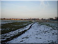
9
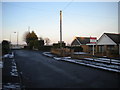
Cogley Lane, Bingham (2)
Cogley Lane as such finishes where it meets the railway, though it continues across a level crossing as a farm track and public footpath. Thus, there is a turning area for cars at the north end of Cogley Lane, which was surprisingly free of snow and ice compared with the rest of Bingham on this day.
Image: © Richard Vince
Taken: 29 Dec 2014
0.13 miles
10
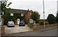
#51 Cogley Lane
The house is On the plot of a previous house nearer the road and railway line. Ordnance Survey documents indicate that in 1966 there was a benchmark levelled at 21.217m above Newlyn Datum on the original house.
Image: © Roger Templeman
Taken: 10 Sep 2018
0.13 miles